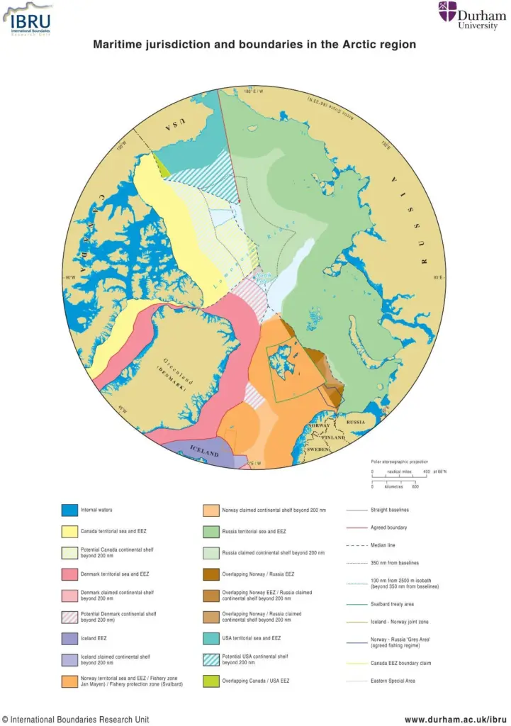
He was speaking after the recent release of the IBRU’s maritime jurisdiction and boundaries map of the Arctic region. ‘The strongest claim at present, based on distance, is Denmark’s’, said Mr Pratt.
To date only Russia and Norway have made submissions to the United Nations Commission on the Limits of Continental Shelf, but Canada, Denmark and the USA are also likely to define their continental shelf limits over the next few years.
Mr Pratt added that despite tabloid releases, the international parties had behaved themselves ‘impeccably’ about claims on the North Pole and its reserves of natural resources.
It is not a straightforward business. Under the 1982 United Nations Convention on the Law of the Sea, Exclusive Economic Zones (EEZs) extend 200 nautical miles from the coastal baseline. Within this area, the coastal nation has sole exploitation rights over all natural resources. But farther out from this, as Pratt said, ‘it gets more complicated’.
The IBRU map and briefing notes (available at www.dur.ac.uk/ibru/resources/arctic) show the current state of play in the region. The map identifies known claims and agreed boundaries, plus potential areas that might be claimed in the future.
Following the Russian submarine mission in 2007 to gather data in support of Russia’s claim that the North Pole is part of the Russian continental shelf, there was a hostile reaction from other Arctic littoral states, prompting media speculation that Russia’s action might trigger a ‘new Cold War’ over the resources of the Arctic.
There are a number of disagreements over maritime jurisdiction in the Arctic region and potentially more as states define the areas over which they have exclusive rights over the resources of the continental shelf more than 200 nautical miles from their coastal baselines. Thus far all of the Arctic states have followed the rules and procedures for establishing seabed jurisdiction set out in the 1982 United Nations Convention on the Law of the Sea.
The IBRU has been an intermediary in many boundary disputes and this large scale mapping of the northern-most part of our hemisphere will hopefully add lucidity to the proceedings.
For further information, email: ibru@durham.ac.uk