
- Subscribe
Get full access to Maritime Journal content
Including the digital magazine, full news archive, podcasts, webinars and articles on innovations and current trends in the commercial marine industry.
- Expert analysis and comment
- Unlimited access to in-depth articles and premium content
- Full access to all our online archive
Alternatively REGISTER for website access and sign up for email alerts
- Industry Database
- Events
Seawork
11th - 13th June 2024Speed@Seawork
10th June 2024Get Set for Workboat 2050
The 25th edition of Europe’s largest commercial marine and workboat exhibition, provides businesses the opportunity to showcase their services, equipment, vessels and supplies to an international audience. Speed@Seawork on Monday 10 June in Cowes offers a sector specific event that showcases fast vessels operating at high speed for security interventions and Search & Rescue. The Commercial Marine Network, in partnership with Seawork and Maritime Journal, introduce Series 3 of ‘Get set for Workboat 2050’. An online conference series of expert panels navigating the waters of decarbonisation compliance and looking at practical applications across the workboat industry. Visit the Seawork Website Speed@Seawork on the Seawork Website View the Conferences on Maritime Journal
Insurers use marine GIS to mitigate risk
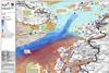
In an exercise undertaken with the World Wildlife Fund, insurer RSA has used the latest Geographic Information Systems to show how technology could help predict the spread of an oil spill – helping both the marine industry and environmentalists predict, and minimise, the damage a spill could cause.
This is premium content
Already a member? SIGN IN now
Sign up for FREE to continue this article…
It only takes a minute to sign up for a free account, and you’ll get to enjoy:
- Weekly newsletters providing valuable news and information on the commercial marine sector
- Access to the Maritime Journal Industry Database
- Monthly Maritime Journal Magazine (Restricted digital edition)
- Website access (3 standard news articles per month)
Get access and more free content sign up today
Does your organisation require more access? Upgrade to a subscription and enjoy unlimited news and additional features.