![MaritimeJournal[Seawork]](https://www.maritimejournal.com/wp-content/uploads/2026/09/MaritimeJournalSeawork.svg)




Dutch coastline redrawn as Maasvlakte 2 takes shape – by Peter Barker
Dutch cartographers face the task of redrawing their maps of Holland due to the country growing in size by a few square kilometres. The Maasvlakte 2 port expansion project in Rotterdam has progressed steadily and what was until recently an offshore island reclaimed from the North Sea now connected to the mainland.
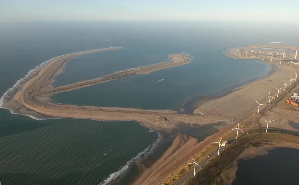
In an operation that is continuing, contractor PUMA has employed a fleet of trailing suction hopper dredgers to move some 50m cu/m of sand from the North Sea to form in part the outer arm of what will be the port’s biggest expansion project since 1970. Some 2,000 hectares of land will eventually be reclaimed, allowing for a potential trebling of container handling capacity for Rotterdam as well as the development of other additional terminals and industrial sites.
Attention is now turning to construction of the first quay wall and more importantly the seawall of the 4km long dike, particularly the north-western section that will be exposed to the worst of the weather and will incorporate a hard seawall. Much thought has gone into the design of this seawall aimed at a more economical and sustainable construction method together with reduced maintenance costs. The less exposed southern part of the seawall will be protected by a soft sea defence of beach and dunes.
The hard seawall base will be a cobble beach comprised of stony dune and light quarry stone reaching the top of the dike at +14 NAP (New Amsterdam Water Level). This will be protected by a block dam extending to +2 NAP, the lower part of which will act as a buffer protecting the stony dune base of the dike. A shallow tidal area will be created between the block dam and the stony dune slope, providing a tranquil area for unique species to develop. The block dam will be constructed entirely of recycled material from the present Maasvlakte seawall.
Quarry stone for the stony dune base will be imported from Norway and to accommodate this substantial operation, a docking area has been constructed at PUMA’s project site in the Yangtzehaven. Every two weeks for the next two years a bulk carrier will arrive carrying 90,000 tons of stone from Bremanger, 200km north of Bergen, which will be distributed to a screening installation and then the sea wall by conveyor belt, swingbelt and dumper trucks. Each unloading process will take around 36 hours.
The last of the six underground bores that will carry various service pipelines and cables under the Yangtzehaven and Euromax Terminal quay wall have now been completed with various contractors working to install cables and a 36 inch gas pipeline (see Maritime Journal October 2009). Diverting services for the existing users at Maasvlakte in this way is necessary because in 2012 the land currently carrying the utilities will be dredged to allow sea access to the new Maasvlakte 2 area.

Related Articles
 OTHER NEWS
 OTHER NEWS
 FEATURES & VIDEOS