![MaritimeJournal[Seawork]](https://www.maritimejournal.com/wp-content/uploads/2026/09/MaritimeJournalSeawork.svg)



Dual doppler radar project aims to provide step change in wind resource measurement
In mid-March, the Carbon Trust – via its Offshore Wind Accelerator Programme (OWA) – announced plans to support a state of the art technology trial to understand the viability of using dual doppler radar to produce high resolution dynamic maps of the wind flow through and around a wind farm.
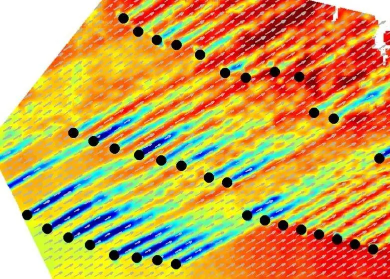
As part of the initiative, which is currently scheduled to run for a total of 18 months, two dual doppler radar units will be installed next year near the Westermost Rough Offshore Wind Farm, currently under construction off the eastern coast of the United Kingdom. The devices will be used to measure a wide range of conditions at the site, with a key focus on wind farm wakes, power curve measurements and wind turbine load validation. The radar will scan back and forth through the wind farm, which is located some 30km offshore, to generate a detailed wind map that is capable of being updated on a minute by minute basis.
A number of technologies are already used to take readings and measurements at various specific points across a wind farm site at any one time – including meteorological masts, as well as fixed and floating LIDAR devices – but the OWA project team reveals that dual doppler radar possess the added advantage of being capable of scanning over the entire site in a short space of time ‘with unprecedented range and resolution, resulting in a holistic snap shot of wind behaviour around a wind farm.’
As Megan Smith, Project Manager, Wakes Research at the Carbon Trust, explains, radar technologies have up until now only been used for limited application in onshore wind farms, but the OWA trial aims to ‘improve the understanding of dual Doppler radar systems’ ability to produce reliable wind measurement when operating in the challenging conditions of marine environments.’
“The potential benefits of the trial include reducing development costs by accelerating the commercialisation of Radar measurement techniques, improving power curve measurements and validation across entire wind farms and improving wake models and so further optimising wind farm layouts,” she says.
DUAL DOPPLER
The scheme forms part of the BEACon (Beamed Radar for Energy Assessment and Site Conditions) research and development project coordinated by OWA partner DONG Energy – and leads on from previous OWA projects on offshore wind measurements, including the floating LIDAR trials and the recently concluded wake effects measurement campaign at Rødsand II wind farm.
In Smith’s view, the BEACon project defines a ‘step-change in the way wind resource could be measured in a wind farm, offering vastly increased insights into how the wind behaves in and around offshore wind sites’ – and she is confident that support from the OWA ‘will bring wider experience to the project to help commercialise this promising technology quicker.’
Smith also points out that dual doppler wind fields, synthesised by two or more radars, will provide an understanding of the complex flow fields within large turbine arrays – and enable the ‘visualisation of turbine-to-turbine wake interaction to be generated, providing a holistic view across the whole wind farm site of how wind flow features entering into and propagating thought a turbine array.’
The prototype dual doppler system is currently being built by SmartWind Technologies and will include two shoreline units – each approximately nine square metres in size and capable of capturing 1GB of data per hour.
“Compare this to LIDAR, which takes point readings from the wind and assumes uniform flow, and generates about 150kB a day. So dual doppler generates an order of magnitude difference in data,” says Smith.
BIG DATA
For Smith, there are a number of key technological, operational and financial advantages of using dual doppler radar. To begin with, she believes it will help companies in the industry gain a detailed understanding of how wind flows through a wind farm – now increasingly recognised as a vital component of project development and valued for its capacity to improve the bottom line by reducing costs through improving turbine layouts, minimising adverse loads on the turbines, and improving confidence in wake models.
“This is about Big Data, but it is also about the speed of the scan pattern, which means you are effectively getting a near real-time view of many different aspects of the forces at work on a wind farm. dual doppler can also scan at different heights so, put simply, if LIDAR is one dimensional then dual doppler is 3D,” she adds.
That said, Smith still admits that dual doppler is ‘unlikely to displace existing wind and meteorological mapping systems.’ Instead, she reveals that it is currently seen as a technology that is ‘complimentary’ to met masts, LIDAR and even satellite-based technologies that are already in use at many wind farm sites around the globe – and ultimately assist in ‘more sharply tailoring a project to its location and in the longer term getting greater understanding about the interactions in wind energy between neighbouring wind farms.’
“The BEACon project is the first time dual doppler technology will have been applied to an offshore wind farm environment. As such this project aims specifically to generate a body of data to show its effectiveness in providing a whole new level of detail on wake effects and wind-flow as yet unseen in the industry. As such we will be looking for how it performs in the challenging conditions presented by the offshore environment,” says Smith.
“The technology will not only improve our knowledge of actual wind resource, it will also provide an influence on many of our models used in optimising wind farm layouts and in the design of offshore turbines,” she adds.
By Andrew Williams