![MaritimeJournal[Seawork]](https://www.maritimejournal.com/wp-content/uploads/2026/09/MaritimeJournalSeawork.svg)




Furuno adds safety features
Japanese marine electronics giant Furuno has added two unique safety features to its electronic chart display systems that are aimed at bringing increased safety to electronic navigation.
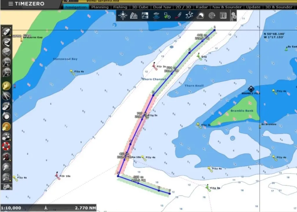
These both involve the use of colour changes to sections of the display if a route plotted or if the current track looks set to take the vessel into danger. These changes may be subtle but they are part of the on-going development of more user friendly electronic navigation systems that has been part of the Furuno philosophy.
For route plotting on the electronic chart the plotted route is shown as a wide band instead of the normal single line. The width of this band can be determined by the user and by using a course band like this, this gives a margin of safety to allow for any deviations in the course that may occur through wind or current effects or perhaps compass errors and does not pin down the plot to a narrow line as is normally the case.
If any part of this band is plotted over shallow water or danger areas then the band changes from its normal green colour to red as a warning that the route may not be safe. This colour occurs when the route is plotted on the chart and/or when the route is actually being followed. The system allows for the user to pre-determine the parameters for the warning such as the depth criteria at which the colour warning is set, bridge heights, types of dangers etc. The width of the course band can also be set by the user for various types of navigation.
The second safety feature that has been added to the display is a similar type of colour coded warning but this time it takes the form of a cone extending out from the current position of the vessel along the heading line. If this cone extends over any danger ahead such as shallow water or rocks shown on the chart then the cone turns from green to red as a warning sign. Again the user can pre-determine the angle of the cone and the distance ahead over which the warning may be given and various depth and other parameters.
Both of these features are applied on the Max Sea Time Zero charts displays that are now used by Furuno. These Time Zero charts can operate on cartography from different sources such as C-Map vector charts and various raster charts with user selection.
Another feature under development will apply to radar display and is likely involve a way in which the radar can determine whether targets shown on the display are approaching or heading away from own vessel or are stationary so that they can be much more readily differentiated. Such a system could be a great help when navigating in crowded waters where there are multiple targets by allowing the user to prioritise the radar targets that may cause a collision threat and allow the operator to concentrate on these.
All of these safety features are part of the on-going development of electronic navigation systems where Furuno brings a practical approach to giving warnings and identifying dangers. These features are applicable to the electronic systems used on small vessels such as workboats and RIBs
By Dag Pike

Related Articles
 ACCESSORIES & EQUIPMENT
 OTHER NEWS
 ACCESSORIES & EQUIPMENT