


Hydrographic Survey – Page 10
-
News
OI postponed
Oceanology International Exhibition & Conference will be postponed and will now take place from 1-3 December 2020 at the ExCel, London, following the escalation of COVID-19 in Europe.
-
 News
NewsSofia offshore wind farm cable route investigation
Fugro’s multipurpose vessel ‘Fugro Pioneer’ recently left the Port of Sunderland in the UK to kick off a 6-month offshore site investigation and survey campaign for innogy’s Sofia offshore wind farm.
-
 News
NewsOceanology International 2020 will salute the past while welcoming the future
Oi organisers are confident of bowling over delegates with half-century celebrations and ‘bigger, better’ content at landmark anniversary event in the ExCel London.
-
 News
NewsXOCEAN acquires hydrographic survey firm
Ocean data company XOCEAN has completed the acquisition of a specialist autonomous hydrographic survey company.
-
 News
NewsSonar added to ASV for offshore surveying
Coda Octopus has successfully integrated its Echoscope4G Surface real-time 3D sonar on AVIC IET’s Autonomous Surface Vehicle (ASV) to enable easier offshore surveying.
-
 News
NewsMarine-i supports two USV ventures in Cornwall
Part-funded by the European Regional Development Fund, Marine-i is a collaborative project providing the infrastructure, expertise and support to enable marine technology innovation in Cornwall and Isles of Scilly.
-
 News
NewsAcoustic positioning technology employed for pipe laying project
A global offshore pipeline installation and subsea construction company will use Sonardyne International’s GyroUSBL acoustic positioning technology for its latest pipe laying contract.
-
 News
NewsMacArtney hydrographic solutions for Geo Group
MacArtney Germany has recently supplied turn-key hydrographic tools, support services and training to the Geo Group which offers onshore geo-engineering and specialist offshore services through 18 subsidiaries in Germany and Poland.
-
News
Backscatter Mosaicking for Teledyne PDS
A new option has been added to the Teledyne PDS applications to enable Side Scan Sonar Backscatter Mosaicking, ensuring that the PDS offering remains at the forefront of sonar processing software.
-
 News
NewsKongsberg outlines holistic Digital Ocean concept
Kongsberg Maritime''s stand at Oceanology International 2018 (Oi18) was dedicated to its Digital Ocean concept which integrates and harmonises the entire journey data takes from the seabed to the office, resulting in a single ecosystem.
-
 News
NewsASV to develop containerised marine lab
ASV Global and the National Oceanography Centre (NOC) are collaborating on a containerised autonomous marine environmental laboratory (CAMEL) for use in developing countries.
-
 News
NewsEOMAP delivers satellite derived bathymetry for European waters
EOMAP, headquartered in Castle Seefeld, near Munich, Germany, recently supplied Satellite-Derived Bathymetry (SDB) to the European EMODnet Bathymetry portal. The data details shallow water regions of the Spanish Mediterranean coast, the Greek Aegean Sea and parts of Libya.
-
 News
NewsSSEN shares seabed data with EMEC
Scottish and Southern Electricity Networks (SSEN) has shared new seabed data with the European Marine Energy Centre (EMEC) having completed seabed surveys on the western edge of the Orkney mainland.
-
News
UKHO welcomes Government report
The UK Hydrographic Office (UKHO) has welcomed the publication of the UK Government’s Foresight ‘Future of the Sea’ report, which outlines a number of recommendations to help the UK utilise its current expertise and technological strengths to foster trade links, build marine capacity across the world and collaborate to tackle ...
-
 News
NewsSercel supplies Sentinel HR streamer to AWI
Sercel recently sold one of its new Sentinel HR high-resolution solid streamers to the Alfred Wegener Institute (AWI), the German research foundation specialising in polar and marine research in the Arctic and Antarctic.
-
 News
NewsCeltic Voyager explores lost landscapes of Irish Sea
As part of the ''Lost Frontiers'' project, a research team from Ireland''s Institute of Technology Sligo and University College Cork recently explored extensive submerged landscapes of the Irish Sea aboard the Marine Institute''s ''RV Celtic Voyager''.
-
 News
NewsSoftware tool automates subsea data processing workflow
Danish software engineering specialist EIVA has released NaviSuite Workflow Manager, a new tool for automatic processing of large volumes of subsea data with minimum human intervention.
-
 News
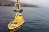
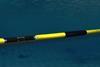
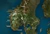
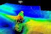
NewsFugro plays key role in Norway's largest coastal highway project
The Norwegian Public Roads Administration (NPRA) recently awarded Fugro a second major contract associated with its largest ever road project, the E39 Coastal Highway. Almost 50km shorter that the existing route, the project is expected to half the journey time of approximately 21 hours.
-
 News
NewsOceanology International on track to consolidate past successes
Running from Tuesday, March 13 to Thursday, March 15 2018 at the ExCel, London, this year’s Oceanology International (Oi) London event – highlighting technological developments including robotics, autonomous systems and advanced sensor technology – is on course to provide a thorough interdisciplinary forum for the exchange of ideas and solutions ...
-
 News
NewsCentury-old wreck uncovered while performing routine Port Company survey
Emily Hand, Hydrographic Surveyor at the Bristol Port Company tells the interesting tale of uncovering the wreck of the ‘Brunswick’ a metal-hulled cargo vessel lost off the UK’s Port of Bristol in 1900 and rediscovered in 2017.