


Hydrographic Survey – Page 28
-
 News
NewsSeawork encounter confirms research connections
Dr Emre Otay, from Bogazici University in Istanbul, was visiting the UK for a holiday with his family in June when they saw the Seawork exhibition advertised locally in Southampton.
-
 News
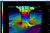
News3D sonar optimises scour protection
The presence of scour (erosion of the seabed surface) around marine structures, including offshore windfarm turbines, is a common occurrence.
-
News
EMODNet hydrography kicks off in Portugal
The latest phase of the hydrography part of the European Marine Observation and Data Network (EMODNet) commenced with a meeting in Lisbon last month hosted by the Portuguese Marine and Atmospheric Institute (IPMA).
-
 News
News‘Fugro Helmert’ launched in Berne
Fugro’s new hydro survey vessel Fugro Helmert was christened and launched last month at the Fassmer Shipyard in Berne.
-
 News
NewsDP training simulation packages delivered
Norcom Technology announced the delivery of its new Ptolemy DPNav software system for simulated training of DP operators at Lowestoft College at Seawork last month.
-
News
Ohmex Seawork Tweet demos
Live tidal and weather tweets on Twitter from a dockside Tweet M8 tide gauge were among innovations featured by Ohmex at Seawork.
-
News
Coastline Surveys-Innovatum joint venture
Major seabed and cable burial surveys for an un-named European wave energy test site are to be undertaken by the Submetrix division of Innovatum of Bury St Edmunds and Coastline Surveys of Falmouth, it was announced at Seawork.
-
News
Royal Navy Libyan surveys
Unchartered wrecks including a 150m vessel at a depth of 22m have been recorded by the Royal Navy’s hydrographic ship, HMS Echo.
-
News
12,000 digital charts on one DVD
The UK Hydrographic Office plans this summer to supply on a single DVD its Admiralty Vector Chart Service (AVCS), with 12,000 digital charts.
-
News
C-Nav tide measurement package
C-Nav, the US GNSS differential Precise Point Positioning organisation with European bases in Norway, Russia and the UK, has developed a real-time tidal measurement package, C-Tides.
-
News
UCL student scholarships
Scholarships worth in total £17,500 are available for students embarking on University College London MSc courses on Surveying and Hydrographic Surveying, beginning this September.
-
News
Hydrographic Society UK Fellowship Awards
The Hydrographic Society UK, which represents organisations and individuals of the domestic hydrographic profession and associated disciplines in addition to maintaining an extensive overseas membership in nearly 50 countries, has elected 15 inaugural Fellows in recognition of their outstanding individual contributions to the industry worldwide over many years.
-
 News
NewsMulti-mission sonar for new research vessel
Underwater positioning specialist iXBlue is to install its latest SAMS-DT 6000 deep tow synthetic aperture mapping sonar aboard a new survey ship currently being completed by Hyundai Heavy Industries in Korea for delivery to the Geological Survey of India (GSI) this September.
-
News
New GNSS compass module
Hemisphere GNSS, the US-Canadian company, has launched a new high performance receiver for heading, positioning, heave and attitude operations in what it calls challenging and dynamic environments, Crescent Vector H200.
-
News
Osiris Projects adds to survey fleet
Bromborough UK based Osiris Projects, which claims to have successfully completed over 600 projects in the UK and northern Europe from inland surveys to multi-parameter seabed mapping projects, is to add a fourth custom built vessel to its fleet in September, Proteus.
-
News
Ocean Business 2013
Over 4,000 visitors from more than 50 countries are expected at this year’s biennial Ocean Business event at the National Oceanography Centre in Southampton UK from 9-11 April.
-
 News
NewsNew Sonic 2020 joins Swathe rental pool
Cornwall UK based Swathe Services has just purchased the newly launched Sonic 2020 multi-beam and ultra high resolution upgrade for the Sonic 2024 to add to its already expanding rental pool.
-
 News
NewsSatellite based bathymetric mapping in Ireland
Proteus, a provider of satellite derived bathymetric mapping and seabed classification services, has been awarded a major contract by the Geological Survey of Ireland (GSI) to deliver complete bathymetric surveys of five Irish bays.
-
 News
NewsNew Kongsberg Multibeam Sounder
EM 2040C, a new compact shallow water multibeam echosounder for high resolution mapping and inspection applications aboard small boats and launches, has been developed by Kongsberg Maritime.
-
News
Digital Hydrography Conference Call for Papers
The Hydrographic Society UK has issued a call for papers to be presented at its two day international conference on Digital Hydrography on the Maritime Web, at Southampton Solent University Conference Centre from 29-30 October.