
In partnership with:


Series 6, Session 2 | 26 March 2026, Rotterdam
Marine mapping demonstrator
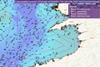
OceanWise, a UK-based supplier of Intelligent Marine and Coastal Mapping Data has announced the release of free, interactive, Marine Mapping product demonstrators available at www.oceanwise.eu/data. Built using OpenLayers, the demos allow the user to pan around a defined area and get a feel for the company’s different data products.
This is premium content
Already a member? SIGN IN now
Register for a FREE one-month trial to continue this article
It only takes a minute to sign up for a free account, and you’ll get to enjoy:
- Weekly newsletters providing valuable news and information on the commercial marine sector
- Access to the Maritime Journal Industry Database
- Website access (3 standard news articles per month)
Get access and more free content sign up today
Does your organisation require more access? Upgrade to a subscription and enjoy unlimited news and additional features.