![MaritimeJournal[Seawork]](https://www.maritimejournal.com/wp-content/uploads/2026/09/MaritimeJournalSeawork.svg)



3D VTS enhances port operational safety
Cardiff based GeoVS has produced what it claims is the world’s first commercial marine three dimensional vessel tracking system, bringing a step change in the monitoring and management of vessels in ports, estuaries and restricted waterways.
Dr. Rafal Goralski, the company’s director of technology said, “For the past 12 years colleagues and I have been grappling with the complex realities of enhancing situational awareness for maritime safety. Only now do technological advances allow the integration of data from many sensors around a port to produce a real time, three dimensional traffic management and visualisation tool. This research has resulted in the development of the world’s first commercial three dimensional real time vessel tracking system.”
It is claimed to provide a more comprehensive picture of vessel movements than existing systems whilst being easier to use, enhancing efficiency and improving safety.
Dr. Goralski added, “Research in Sweden has shown that the use of three dimensional charts leads to a significant reduction in human error and a similar increase in the operator’s efficiency.
“The system, which we call C-Vu 3D VTS, works either on its own or as a bolt on to existing two dimensional systems, and can be used by port operators, ships’ pilots and other navigators.”
Currently vessel tracking systems largely rely on radar signals and present a two dimensional picture of vessels moving within the designated area on an electronic chart, displayed on computer screens. They allow port operators or Coastguards to see the vessels and monitor and to control their progress. But these systems have significant limitations.
They do not identify individual vessels, and the performance of radar systems can be adversely affected by weather. When vessels are close together, their radar blips can merge. They only show the surface picture, not hazards that lie beneath the water, and thus rely upon the operator’s local knowledge. Neither do they give tidal information, again relying on the operator’s knowledge and experience, which varies from operator to operator.
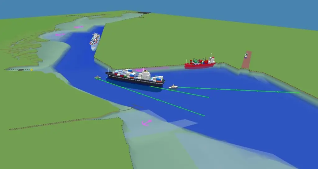
GeoVS’s new system, C-Vu 3D VTS, is a further leap forward. The picture it presents to operators is more encompassing, clearer and straightforward to understand.
It presents a three dimensional image and also gives realistic representations of all the vessels, the waterway, port installations and navigational marks such as buoys. At the click of a mouse it shows the underwater picture and hazards vessels may encounter. This includes critical real time tidal data, so the operator knows exactly the depth of water beneath the keel of each vessel.
GeoVS’s system draws on information from existing radar systems, and supplements this with inputs from tidal gauges, meteorological stations, and radio based automatic identification systems, which are now mandatory for all commercial vessels.
Thus it presents a comprehensive real time picture of what is happening in the waterway, identifying individual vessels, in a way that is straightforward to understand. It improves situational awareness, reduces fatigue, particularly eye strain so enhancing operators efficiency.
The system automatically records the picture and can store it for up to 10 years. This brings big benefits as a training aid and for investigation and analysis of incidents, particularly if there is litigation.
Related Articles
 ACCESSORIES & EQUIPMENT
 ACCESSORIES & EQUIPMENT
 ACCESSORIES & EQUIPMENT