




NavSim/C-Map in Navigation Software Partnership
NavSim Technology Inc, a Canadian manufacturer of advanced PC navigation systems has partnered with C-Map to create BoatCruiser 2.0, a PC navigation software product based upon C-Maps proven MAX on PC technology, and one that supports both C-Maps highly acclaimed MAX technology as well as their popular NT+ digital charts.
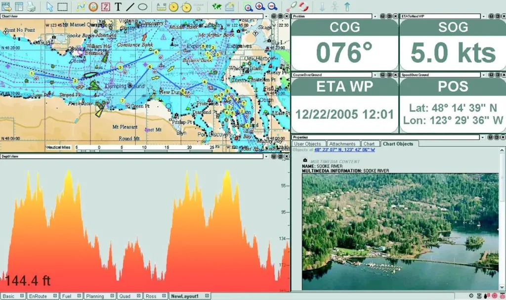
Ideal for commercial and leisure mariners alike, BoatCruiser 2.0 provides all the detail of C-Map’s new MAX coverage, including Tide and Current Predictions, displayed with fully animated, coloured arrows on the chart, and Dynamic NavAids, which light up and flash in exactly the right colours, ranges and sequences based on the boat’s position and distance from them. BoatCruiser 2.0 features MAX’s Perspective View, but to a greater extent than on other MAX systems, as the user may now adjust the ‘bird’s eye’ viewing angle to suit their personal preference. Also included are aerial photographs and/or detailed drawings of popular marinas, giving boaters a clearer idea of the approach, and subsequently, added confidence.
As well as general MAX charting detail, BoatCruiser 2.0 offers navigation features that would normally be found in much more expensive navigation programs, including support for AIS, Depth Sounder, Autopilot and ARPA/MARPA compatibility, along with excellent GPS tracking capability. Another feature is that the user receives a complimentary MAX region of their choice with the initial purchase. They also have the option of purchasing a C-Map card reader so that their existing C-Map cartridges may be used in conjunction with the new software.
MJInformation No: 21933
Related Articles
 ACCESSORIES & EQUIPMENT
 ACCESSORIES & EQUIPMENT
 OTHER NEWS