![MaritimeJournal[Seawork]](https://www.maritimejournal.com/wp-content/uploads/2026/09/MaritimeJournalSeawork.svg)





High resolution bathymetry model of English Channel
Marine GIS services provider SeaZone took a major step forward towards its aim to create a high resolution and accurate bathymetry model of the UK Continental Shelf by completing the first phase of its Bathymetry Improvement Programme for the northern English Channel between South Foreland and Land’s End.
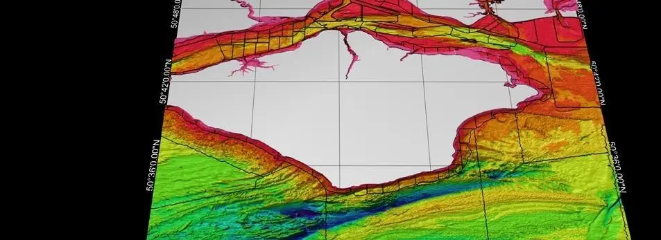
The Civil Hydrography Programme of the Maritime and Coastguard Agency, the Channel Coastal Observatory, the Port of London Authority and various other ports, harbours and third parties contributed survey data to the programme.
The new bathymetry model will become a core reference dataset in SeaZone’s digital marine mapping product, HydroSpatial. With increasing pressure on the marine environment and the requirement to maximise value from existing public sector information holdings, the new model in particular and HydroSpatial generally are already proving to be important tools to support offshore renewable energy development, marine planning and policy making. The bathymetry model, believed to be the first of its kind, is created from ‘best available’ digital survey bathymetry data from the variety of different sources. It is being used by British Geology Survey to improve our understanding of sea bed geology and by Cefas (and others) as input to habitat mapping.
SeaZone has spent the past three years gathering and digitising data, going as far as identifying and gaining permission to use and capture survey sheets (also known as fair sheets) stored in archive at the UK Hydrographic Office. In total, SeaZone has invested in the capture of over 400 surveys to create this unique database of the UK’s underwater terrain. The data represents the most detailed water depth data available, either from modern multibeam surveys or single beam surveys dating back to 1970. All of the data used in the work has been collected to the IHO’s International Survey Standard, S-44, and quality controlled at the UK Hydrographic Office or another competent authority. By using survey data as input, the new model is more accurate than depth data displayed on traditional navigational charts, which is widely known to be coarser in resolution and conservative in depth.
To date, SeaZone has collated over 2.2 billion soundings from 5,000 surveys. Accurate area extents and metadata are created for each survey and the metadata published to the MEDIN portal, as well as being used internally by SeaZone and its customers. The data and metadata is used as input to SeaZone’s Digital Survey Bathymetry (DSB) data product and as input to the bathymetry model. From this unique Oracle database, significant resource is invested to create a single seamless surface of sea bed elevation representing the most up to date and dense data available. The work, typically known as ‘survey de-confliction’, is undertaken using specially designed GIS software developed at SeaZone to read survey points directly from Oracle.

Related Articles
 OFFSHORE RENEWABLES
 OTHER NEWS
 MERGERS & ACQUISITIONS