


Hydrographic Survey – Page 9
-
 News
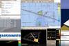
NewsSurvey software for FarSounder’s sonars
Users of FarSounder’s Argos Forward Looking Sonars (FLS) can now benefit from valuable survey software.
-
 News
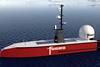
NewsUSV surveys monitor port changes
A new partnership will help the development of Unmanned Surface Vessels (USVs) in performing hydrographic surveys to monitor changes at a UK harbour.
-
 News
NewsTwo SEA-KIT USVs for Fugro
A UK builder of uncrewed surface vessels has passed a significant milestone with an order of two vessels from the world’s leading geo-data specialist.
-
 News
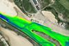
NewsYellow River provides murky test for unmanned technology
A recent first full survey of the world’s most sediment laden river has used a combination of unmanned aerial and surface vessels.
-
News
Software expiry
CodaOctopus has served an end of life notice on its Underwater Survey Explorer (USE) Version 5 and 6 and Version 2 of its Construction Monitoring System (CMS).
-
 News
NewsNew depth map over the Arctic Ocean
Details of a new depth map of the Arctic Ocean have been published in the nature journal ''Scientific Data''.
-
 News
NewsOffshore wind site investigations begin
A four-month marine site characterisation campaign has begun at two major offshore wind development sites in the UK.
-
 News
NewsWorld’s smallest integrated multibeam echosounder
Picotech has announced the launch of its PicoMB130 Surf, claimed to be the world’s smallest integrated Multibeam Echosounder.
-
News
Teledyne distributorship
Teledyne has announced that Groove Associates Ltd is now appointed an official distributor for Teledyne Impulse-PDM - this includes Teledyne Impulse & Teledyne Impulse-PDM, products & connectors.
-
 News
NewsUSVs carry out scour assessments
Multi-Beam Echo-Sounder (MBES) and mobile laser scan surveys have been successfully carried out using USV''s in Wales to assess the scour extents at the foundations of multiple structures and to provide additional information on the structures above surface.
-
 News
NewsSite characterisation survey key to offshore wind site evaluation
According to Applied Acoustic Engineering, one of the critical elements in site selection for offshore windfarms is the evaluation of the presence of any geological restrictions.
-
 News
NewsPort and harbour above water survey investment
ABP’s Ports in the North West UK have added value to their survey capabilities by investing in a Carlson Merlin LiDAR scanning system.
-
 News
NewsVessel detours to make unscheduled volcano survey
A Netherlands hydrographic survey vessel has made a 10 day detour to monitor an active underwater volcano in the Mozambique Channel.
-
 News
NewsEdgeTech promotion
EdgeTech, a specialist in high resolution sonar imaging systems and underwater technology, recently promoted Gene Andella to the role of Customer Service Manager.
-
 News
NewsUnmanned hydrographic survey operations
Amsterdam-based survey company Deep BV will upgrade one of its survey vessels with a Sea Machines SM300 autonomous control system.
-
 News
NewsSonardyne creates new group
Sonardyne has formed a new parent company to increase the breadth and capabilities available to customers across the organisation’s growing family of independent subsidiaries.
-
 News
NewsDepth data management system delivered
A developer of marine mapping software has delivered a depth data management system to a European hydrographic office.
-
 News
NewsROV and survey support contract
A Geo-data specialist has secured a major ROV and survey support contract.
-
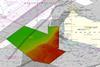
 News
NewsKeeping Netherlands waterways navigable
Maintaining the narrow navigational channels through the shallow tidal flats of the Wadden Sea in the Netherlands is a constant battle, due to the high rate of sediment deposition.
-
News
AI cleans sonar noise
Teledyne CARIS has released its HIPS and SIPSTM 11.3 software. This upgrade will introduce the first-ever COTS (commercial-off-the-shelf) release of an AI solution for classifying and cleaning sonar noise.