![MaritimeJournal[Seawork]](https://www.maritimejournal.com/wp-content/uploads/2026/09/MaritimeJournalSeawork.svg)




Autorouting from Navionics
For all workboats and similar craft it is a legal requirement to develop a passage plan before sailing. The requirement entails plotting the proposed route, checking the weather and tides and looking at alternative ports among other things. The aim is to ensure that the vessel the crew are well prepared to undertake the proposed voyage.
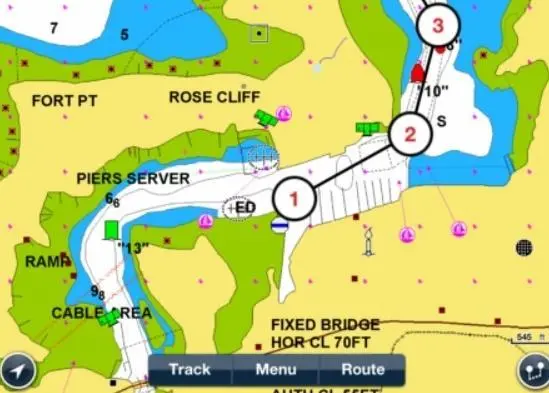
Working on the passage plan can be a necessary chore before sailing even when using electronic chart systems. Now Italian chart specialist Navionics has come up with a solution that will at least take some of the work out of the requirement, their Auto-Routing System. The basic operation is simple, just plot the starting point, usually the harbour you are leaving and the finish point of the voyage, usually the harbour or work area you are heading towards.
The Auto-Routing will then plot what it thinks is the best route between the two places. You need to inform the plotter what is the safe draft of your vessel and the air draft if that might be relevant. You can make the draft the minimum depth of water that you want the encounter along the way and the plotter will then propose what it thinks is the best route. You can also enter your expected fuel consumption and the plotter will estimate the amount of fuel you will need for the voyage.
Now you will need to work your way carefully along the proposed routes on a large chart scale to ensure that there are no hidden dangers along the way and that the proposed route is safe for navigation. It is simple to modify the route, simply locate a waypoint you want to change and drag it to a new position and the route will be adjusted accordingly. In this way you can allow a wider distance off a headland or other danger. The various waypoints will then be listed on the screen and you set the required courses to follow them.
Navionics emphasises that this Auto-Routing is an aid to navigation and that the user must check out and confirm the proposed route before using it. The system will work with the Navionics IPhone and I Pad Apps as well as with most chart plotters.
By Dag Pike

Related Articles
 ACCESSORIES & EQUIPMENT
 OTHER NEWS
 ACCESSORIES & EQUIPMENT