![MaritimeJournal[Seawork]](https://www.maritimejournal.com/wp-content/uploads/2026/09/MaritimeJournalSeawork.svg)






Living on the edge: Plans to save town from coastal collapse
Works to avoid ‘catastrophic landslips’ on the Isle of Wight are being planned with a £150 million tender to try and protect the town of Ventnor from its own geological make-up.
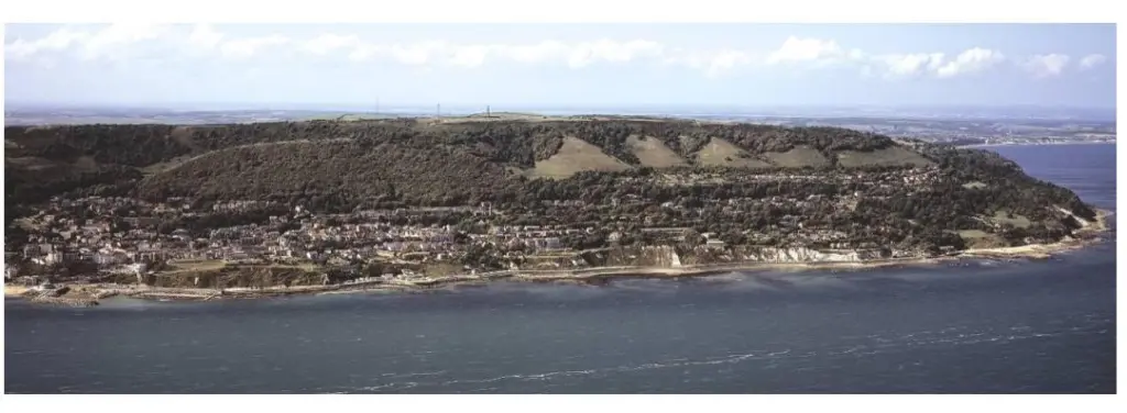
Ventnor sits on the largest urbanised landslide complex in north-western Europe thanks to the Victorians’ decision to build it there, ironically for the very reasons that pose such risks to it today.
It sits on the Ventnor Undercliff, which is a series of ancient landslides stretching around 12km from Blackgang to Bonchurch. Rather than being a single stable slope, it consists of multiple deep-seated landslide blocks that continue to move slowly or episodically over time.
Geological studies by the British Geological Survey (BGS) show that these landslides occur where harder rocks – Chalk and Upper Greensand – overlie weaker Gault Clay, creating a sliding phenomenon.
The layers slope down towards the shore, so the foot of the cliff is being eroded by waves in what is known as ‘toe erosion’, where the base of the slope is cut away until the ground above loses support and moves backwards.
Rainfall and groundwater are equally important. Water entering cracks and weak clay layers increases pressure underground and reduces friction, allowing the slope to move more easily. Following very wet periods, instability can rise sharply, and this is what the town of Ventnor is facing today.
Victorian health
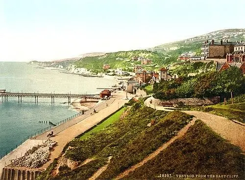
But Victorian planners saw enormous advantages in the geographical location and didn’t know about – or ignored – the instability.
The landslide terraces created a south-facing, sheltered landscape protected by high downs behind, producing a mild micro-climate, warmer and less exposed than many other parts of England.
During the 19th century, when climate and sea air were widely believed to aid recovery from illnesses such as tuberculosis, Ventnor gained a reputation as a health resort. Tourism guides and historical accounts describe it as a fashionable destination, praised for its ‘health-giving’ air and climate.
And while Victorian developers may have noticed occasional landslips, they did not fully understand deep-seated landslide systems that move slowly over decades; instead they allowed infrastructure to be built across the natural terraces and scarps that had been created by landslides themselves.
Shoreline management
The dangers of coastal erosion, deep-seated landslides, groundwater pressure and infrastructure instability facing Ventnor are so complex that no one measure can solve all: but one thing is certain, ‘No Active Intervention’ (NAI) is not an option.
“The NAI scenario would result in widespread loss of properties, businesses, shoreline access roads, esplanades and footpaths due directly to coastal erosion in epochs two and three,” says the Isle of Wight Shoreline Management Plan.
“More importantly, ongoing erosion would also be likely to trigger significant ground movements and damages to the terraces of the town above following loss of the coastal cliff support, with risks worsening progressively over the next 100 years.
“This NAI scenario is unacceptable in this developed eastern area of the Undercliff.”
To tackle the issues, the Environment Agency and Isle of Wight Council have released £150 million (€172 million) for a second phase of works.
“The work will involve concrete esplanade repair, installation of wave return walls and installation of a rock revetment along most of the defences,” says the Environment Agency. “Challenges include working in a constrained access site, delivery of rock by sea, a high energy marine environment and consideration of marine environmental designations adjacent to the site area.”
There is huge scope: a tender expected to be issued next year will include sea defence construction, coastal defence, flood defence maintenance, breakwater building and a host of other works.
More information is available here.
Related Articles
 INDUSTRY NEWS
 MARINE CIVILS
 MARINE CIVILS