![MaritimeJournal[Seawork]](https://www.maritimejournal.com/wp-content/uploads/2026/09/MaritimeJournalSeawork.svg)






LiDAR monitors Corsican coastal erosion
A new bathymetric survey of the Corsican coastline has been commissioned to provide detailed information about ongoing coastal erosion on the Mediterranean island as well as to assess the impact of manmade structures both on future erosion and navigation safety.
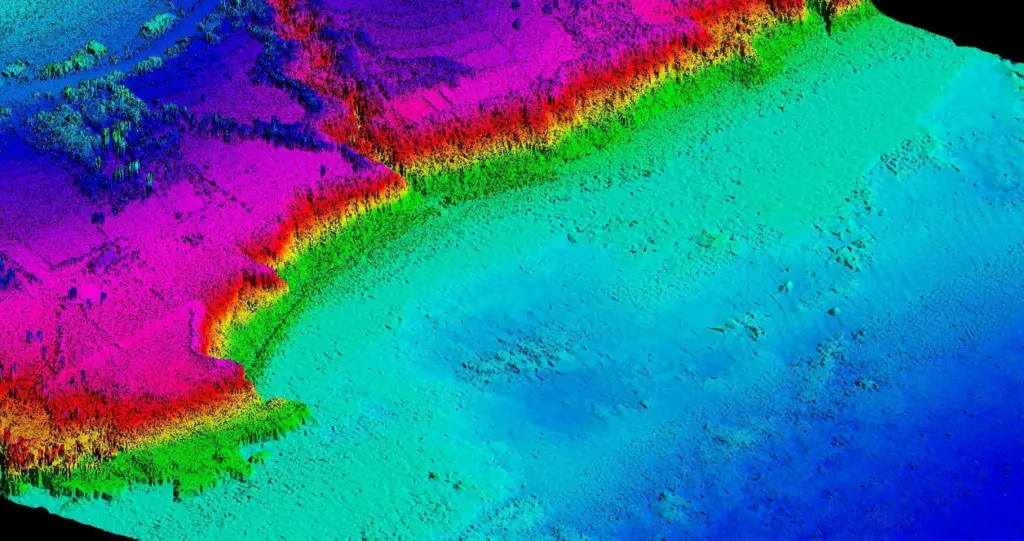
BRGM in partnership with OEC (Office de l’Environnement de la Corse) and with the contribution of AERMC (Agence de l’Eau Rhône Méditerranée Corse) have appointed UK aerial imaging specialist BLOM and its Hawk Eye II scanning device to undertake an aerial LiDAR survey of the Oriental Coastal Plain of Corsica, providing some 120km² of new data.
Subject to intense meteorological events, including windstorms and heavy waves, Corsica has seen significant erosion of its coastline in the past 25 years and a decline in the surface area occupied by seagrass beds.
Key to the success of this new initiative will be the specialist Hawk Eye II scanning device, with its capability to capture precision data from both land and seabed terrain simultaneously, in just one aerial pass. Bathymetric and topographic data will be used to create a continuous digital elevation model of both the sea and the contiguous land. For this particular project data from Hawk Eye captured over a period of just seven days is intended to provide important insights into the condition of the coast line, including the spatial imprint of manmade structures such as breakwaters and their consequences on the environment as well as that of coastal houses and other developments.
In addition, the fine detail in the cloud points’ density produced though the LiDAR survey will help identify very small scale variations in the height and roughness of the underwater ground surface, exposing the morphology of the sand dunes, identifying any sandbars and producing data that can then be employed to develop hydrodynamic models to tackle any local build up of sediments.
This investigation, included in the Corsican Coastal monitoring network (OEC-BRGM), will provide the first accurate DEM of the oriental coastal plain. This information will permit the description of complex coastal morphologies and the develop of numerical tools for the understanding and prediction of coastal hazards (erosion, marine inundation, storm impacts) and coastal risks. High quality and high resolution datasets will help to better prepare coastal planning and adaptation strategies.
Achieving accuracies in excess of +/- 25cm in seaward areas, and in depths of between 3m and 55m, Hawk Eye II laser data can also be used to determine and analyse the geology at the sea bottom. It can be employed to accelerate the availability and accuracy of nautical charting, identifying the shape of the seabed as well as pinpointing the position and exact size of any manmade structures or obstructions. The technology has enhanced the feasibility, quality and speed of coastal and nautical mapping. Operating at a claimed 60% of the cost of traditional hydrographic survey, it is assisting in providing high quality information to improve understanding of environmental and conservation projects, habitat management and coastal engineering and exploration.
Blom’s data capture and processing for the new Corsican initiative is expected to be completed this month.
Related Articles
 INSURANCE, LEGAL & FINANCE
 EQUIPMENT
 EQUIPMENT