![MaritimeJournal[Seawork]](https://www.maritimejournal.com/wp-content/uploads/2026/09/MaritimeJournalSeawork.svg)






Data buoys enjoy Atlantic evolution
A report out this month on an array of long term data buoys in the Atlantic shows that it has exceeded expectations – despite fishing damage, vandalism and bird droppings – and that demand for the information is growing with over 50,000 downloads of information in one year alone.
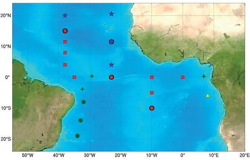
The Pilot Research Moored Array in the tropical Atlantic (PIRATA), with its original 12 Atlas buoys, was first deployed in 1997. Developed as a multinational observation network established by Brazil, France and the United States, its aim was to improve our knowledge and understanding of ocean/atmosphere variability.
However, the buoys were not placed for purely scientific reasons. There has also been a need for improved prediction of the tropical Atlantic climatic system and its impact on surrounding countries. The data acquired from the buoys is widely used in operational weather, ocean, and climate forecasting that potentially provides significant economic benefits to countries surrounding the basin. For example, the array has been instrumental in identifying the factors that contributed to the unusual 2005 Atlantic hurricane season, which was the most active and destructive on record.
Almost predictably, there have been problems. Two buoys were rapidly taken out of commission due to damage probably caused by vandalism. Rain and conductivity sensors have had difficulties with noise contamination, fouling from biological growth and bird droppings. In addition, both the rainfall and wind sensors are high on the buoy tower and relatively exposed to tampering and damage from fishing vessels when they tie up to the buoy. However, although lower in the region of the Gulf of Guinea, data return is typically 75 to more than 90% in the central, western, and southern portions of the array.
With hardware, software and protocols based on the Pacific TAO array, PIRATA has evolved. More data collecting equipment and three extensions (in the Southwest, the Northeast, and the Southeast) have been or are being added to the array, which has led to an additional 30% increase in data throughput.
The information available to users also went up as the data delivery system (from Service Argos) began to use a multi-satellite relay system and NOAA/PMEL reprogrammed its buoy data transmissions. As it evolved, information that has only recently shown to be crucial to certain aspects of the Atlantic system, such as freshwater influxes, has become available to users online.
Demand for the information is growing. In 2006, (the most recent year for which statistics are available), an amazing 52,854 PIRATA data files were delivered via the website.
PIRATA will now be sustained for the foreseeable future as part of GOOS and GCOS. The report shows that it has advanced beyond a ‘Pilot’ programme. As such, the PIRATA acronym will now stand for ‘Prediction and Research Moored Array in the Tropical Atlantic.’
Related Articles
 VESSELS
 MARINE CONSTRUCTION
 VESSELS