![MaritimeJournal[Seawork]](https://www.maritimejournal.com/wp-content/uploads/2026/09/MaritimeJournalSeawork.svg)





Making room for the river
A nine year €2.3 billion project in the Netherlands aims to reduce the risk of major flood damage from changing environmental conditions, including rivers having to process increasing levels of rainfall, snow and ice.
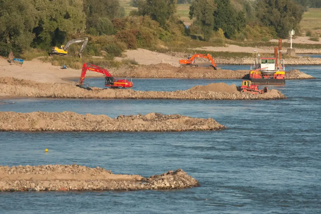
The project, known as Room for the River, involves the Rijkswaterstaat (Directorate-General for Public Works and Water Management), provinces, municipalities and waterboards engaging in projects at 30 separate locations in the Netherlands that breaks the established traditions of flood risk management dating back to the 9th century by adopting measures including actually widening the rivers, an approach that is attracting interest from countries as far away as China and Panama.
It is perhaps understandable that ‘The Netherlands’ translates into low-country given half its surface area is less than 1m ASL and the highest point just 320m ASL. The country is in effect a river delta, described as Europe’s drainpipe and discharge point for a number of the continent’s main rivers. Around four million residents are at risk from flooding, not to mention the implications for agriculture and industry. It is worth remembering however that the greatest threat actually comes from the sea and work is constantly underway to reinforce defences on this front, but that is another story.
LESSONS LEARNED
History reminds the Dutch of the importance of (literally) keeping on top of the problem. In recent memory 1,835 lives were lost and 70,000 people evacuated during storms and floods in 1953. Anxious times were faced in 1993 and 1995 due to high water levels which the dykes just managed to hold. A quarter of a million people were evacuated on these two occasions. The worst case scenario is truly daunting. A breach in a coastal or river dyke could inundate half the country, endangering the lives and livelihoods of ten million people living in areas below the benchmark NAP (Amsterdam constant level) with a potential flood damage bill of €165 billion. Room for the River aims to increase discharge capacities from rivers including branches of the Rhine, from 15,000 m3/sec to 16,000 m3/sec.
To understand the alternative approach it is worth looking briefly at the history of water management in the Netherlands. Waterboards are the oldest form of democratic government in the country, dating back to the 13th century. The earliest safeguards involved constructing artificial dwelling mounds known as terpen along with reclamation of peatlands. This caused land masses to subside however, leading to further flooding and the introduction of the now well established system of dykes, containing the water and allowing removal by pumping and drainage through sluices, etc. A graphic illustration of this is when standing on a dyke next to a waterway where the land on one side can be visibly lower than the water level on the other. There has also been a continual decrease in the area available for rivers during past centuries in the Netherlands, more people than ever are now living behind dykes on land that has over time, sunk due to soil subsidence.
Water management in the Netherlands is a complex subject. As well as the obvious requirement to keep the population safe, there are issues for commercial consideration including protecting the interests of waterway users (leisure as well as commercial) along with agricultural industries that are greatly affected by the profile and behaviour of the waterways. The country is likened to a gateway for water, described as ‘a control panel’ managing a mosaic of rivers, canals, lakes and (dammed) estuaries directing water from the Rhine and Meuse to locations of their choice. A substantial amount of water is stored in Lake Ijsselmeer for production of drinking and irrigation water. Water levels have to be sufficient for commercial shipping while at the same time saline intrusion of groundwater has to be controlled and seawater kept at bay. An example of this constant balancing act is in the south western Delta region where sluice gates at the Haringvliet are operated in such a way as to control the rate of river water discharge through Rotterdam and the Nieuwe Waterweg, in turn counteracting saltwater incursion at that location.
Room for the River is as much about enhancing the economic benefits from inland waterways for the Netherlands as flood protection and is seen as a major contributor to the country’s aim to double foreign profits from the water sector by 2020. The objects are threefold. By 2015 the branches of the Rhine must be able to safely accommodate a normative river discharge of 16,000m3/sec (floods do not stop at borders), the measures must improve the spatial quality of the river region and thirdly, the extra space rivers are likely to need during the course of this century must remain available.
NINE BASIC MEASURES
Room for the River involves nine basic measures; floodplains are lowered increasing room for the waterways in high water situations, dykes are relocated further inland widening floodplains, dykes on the riverside of polders are lowered creating extra space for excess water flows, riverbeds are deepened creating more room for the water, dykes are reinforced where river widening is not feasible, river groynes are lowered to speed up the rate of water flow, riverbed obstacles are removed also increasing water flow, provision of temporary water storage at the Volkerak-Zoommeer when the storm surge barrier is closed and finally a high water channel dyke to discharge water via a separate route.
With Room for the River involving work at 30 locations throughout the Netherlands space does not permit including detail of each one, but a look at some individual projects paints a representative picture of various measures.
EXAMPLES OF MEASURES
Additional room will be created for the rivers Ijssel, Rhine, Lek and Waal. Widening the river through relocating dykes at Overdiep on the Waal in effect reverses land reclamation and demonstrates that such measures do impact the local community. Affected farms are being relocated to man-made raised areas (terps) along a new dyke. The dyke on the north side of the polder will be lowered creating additional room for the river. It is anticipated that water will flow into the polder every 25 years, lowering high water levels in the Bergsche Maas by 25cm in the Overdiep polder area. As well as providing additional room for the Maas the polder will be available for sustainable agricultural use. Relocation of businesses is not always universally embraced. Some have agreed to move to the new terps and have subsequently not regretted moving, others have opted to relocate to a different area entirely. Work commenced in 2010 and is due to end in 2015, involving three contractors; Van Oord Nederland BV, GMB Infra BV and Firma Oldenkamp BV.
The groynes on the Waal stabilise the river while ensuring a navigable route for river traffic, they do however obstruct the river and increase water levels. Lowering the groynes is one of Room for the Rivers measures, freeing up water while at the same time maintaining adequate depth for shipping. A total of 750 groynes along a 75km section of the river between Pannerdensch and Gorinchem are being lowered by around one metre. This will result in a six to 12 centimetre reduction in extreme water levels when the 16,000m3/sec water arrives at the Rhine’s portal at Lobith. Upon completion, the groynes will be submerged for two-thirds of the year making the Waal appear much wider. They are currently visible for most of the year. Three contractors will be involved; Gebr van der Lee, Paans Van Oord and another yet to be decided.
An important feature of Room for the River is the management of water storage facilities at Volkerak-Zoommeer in South Holland. As mentioned, the greatest threat of flooding comes from the sea rather than excessive river discharge levels. Extreme weather, particularly when coinciding with high tides, can lead to closure of the storm surge barriers. While reducing the risk of flooding from the sea, it also stops the natural flow of river water out to sea.
Should circumstances conspire to also coincide with extreme river discharges, water levels in the Haringvliet and Hollandsch Diep, to the south west of Rotterdam, would rise to unacceptably high levels. This risk is to be reduced by temporary storage of river water in the Volkerak-Zoommeer. Bad weather and increased river discharge periods can last for extended periods but the tidal cycle is relatively short and importantly, predictable, and when the storm surge barriers are reopened, river water can flow out to sea again. The chances of these circumstances occurring are put at one in 1,400 per year but it is now considered that the effects of climate change and consequential impact on water levels could increase the risk. Looking ahead, it is expected that water storage may have to be implemented more often to ensure flood protection in the area around Hollandsch Diep and Haringvliet. The project was launched to the market in 2012 with work commencing in 2013.
Each of Room for the River’s 30 projects are naturally unique to the location, as are the consequences for local communities, it is not always bad news however. Nijmegen is located on the Waal at one of the narrowest river bends in the country. On the south bank, opposite Nijmegen is the village of Lent, the river here being just 450m wide compared with 1,000m elsewhere. This bottleneck results in large volumes of water having to force their way through the narrow passage at periods of high water and is one of the areas where the river is to be widened through relocation of the dykes. A new channel will also be excavated in the floodplain on the Lent side of the river, two measures that will increase flood protection for the village (some 350m inland) through a lowering of the water level in the Waal by 35cm. Two main contractors, Dura Vermeer and Ploegam BV are combining to complete this work.
For Nijmegen however, this particular project has created a catalyst for integral development of the area. The excavated channel will create an island between the Waal and the channel and the opportunity is being taken to build two new bridges to link to the ‘mainland’. A unique new river park with space for nature and conservation will be developed, blended into a new residential neighbourhood on the north shore. For Lent this will mean a new quayside and waterfront.
Forty kilometres east of Rotterdam on the Merwede is the town of Gorinchem, centre for a number of shipbuilding, repair and other marine related industries. The water level at Gorinchem however needs to be lowered by 30cm and reverting reclaimed land of the Noordwaard polder to water through depoldering will increase the river’s discharge capacity at high water levels. The dykes are to be partially lowered creating inlets and outlets, diverting some of the volume upstream from the Nieuwe Merwede. It is estimated this ‘through-flow’ area will be flooded once every 100 to 1,000 years. While some agricultural businesses will be affected, a feature is that relocation of some homes, and adaption of others will allow residents to stay in the polder at such times. Work commenced in 2012 with completion due in 2015. The main contractors are Royal Boskalis Westminster BV and Martens en Van Oord, along with two other companies, part of the VolkerWessels Group, Van Hattum en Blankevoort and Gebr van Kessel Wegenbouw.
Finally, river widening through dyke relocation at the Hondsbroeksche Pleij at Westervoort has drawn considerable interest from abroad through its focus on nature, culture and historical aspects. The area plays a key function distributing water between the lower Rhine and the Ijssel River and is vulnerable to extreme water discharges. What was previously a floodplain has now been reconfigured as flood protection, the dyke being moved 250m by contractors de Vries & van de Wiel (part of the DEME Group). Water distribution is now regulated by a damn construction, completed by Van den Biggelaar, at the southern end of the high water channel.
By Peter Barker
Related Articles
 FEATURES & VIDEOS
 MARINE CIVILS
 OTHER NEWS