


Testing has confirmed the Geometrics MagArrow magnetometer to be efficient at low altitude flights.
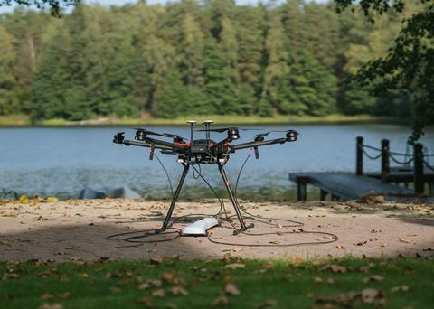
SPH Engineering, developer of UgCS ground control software and solutions for industrial applications, as part of its strategy to expand its range of supported sensors, completed tests of the Geometrics MagArrow magnetometer together with a radar altimeter and True Terrain Following technology for surveys requiring extremely low altitude (1-2 meters between a sensor and surface).
Alexey Dobrovolskiy, CTO of SPH Engineering, said: “As of today, MagArrow has been typically used for surveys conducted at high altitude, like minerals prospecting or abandoned wells detection. We can confirm with confidence to UgCS and Geometrics clients that True Terrain Following and MagArrow are fully compatible allowing using the magnetometer in additional scenarios requiring low altitude to gather high resolution data.”
Two scenarios
Tests were conducted in Latvia to find underground infrastructure, and find magnetic anomalies under the bottom of the lake. Infrastructure detection tests were conducted at SPH Engineering’s own test ranges over known targets - different metallic pipes, barrels, and smaller metallic items.
During the tests over lake magnetic anomalies were detected at half a meter under lake bottom, water depth 1-3m. The existence of anomalies was confirmed using a low-frequency GPR system.
In terms of R&D adjustments, UgCS Industrial Solutions determined the optimal position of a radar altimeter on a drone carrying a MagArrow, which is affixed to the UAV using suspension cables.
The True Terrain Following system was fine-tuned for this application, and this simplified the workflow to refine the coordinates in the magnetic data with the help of more precise position tracks from UgCS SkyHub onboard computer.
By Rebecca Jeffrey