


Hydrographic Survey – Page 42
-
 News
NewsKey mapping role for ABPmer
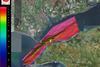
ABP Marine Environmental Research Ltd (ABPmer) in the UK is developing nationwide digital maps of human activities in the marine environment. The specific layers relating to commercial fisheries, renewable energy, mariculture and archaeological interests are being developed to support marine protected areas (MPAs).
-
 News
NewsNew Sonardyne transponders for Subsea 7
category' , ' 1252581180329' , ' ); } return false; s new Compatt 5 Max subsea positioning transponders for deployment in BP’ s Skarv field offshore Norway, initially to provide precise positioning for installation of various underwater templates in depths between 350m and 450m.
-
News
French Navy orders Valeport systems
SHOM, the French Navy’ s Hydrographic & Oceanographic Service in Brest, has commissioned 14 miniSVS sound velocity sensors and five miniSVT sound velocity with temperature sensors from Totnes UK based Valeport, which has been a preferred supplier of this type of instrumentation to the organisation for a number of years.
-
News
Bulgarian coastline surveys
Blom Bulgaria and Blom Aerofilms of Cheddar in the UK are to collaborate in major surveys of the Bulgarian Black Sea coastline using bathymetric laser scanning (Lidar) techniques in a project commissioned by Bulgaria’ s Centre for Underwater Archaeology, which is responsible for protection and preservation of national underwater cultural ...
-
News
updates digital video handbook
The International Marine Contractors Association, which now has nearly 600 members in 52 countries, has updated its definitive handbook on digital video. The new version provides an understanding of the latest digital video technology developments, the benefits available over existing analogue recording methods, and practical applications.
-
 News
NewsRovlatis completes trials
Rovlatis, a new ‘ smart’ ROV designed for international marine applications by the University of Limerick’ s Mobile & Marine Robotics Research Centre (MMRC), which was reported in these columns earlier this year, has now completed secondary trials and demonstrations in Limerick Dock attended by investors and prospective partners.
-
News
Teledyne TSS Swedish & Turkish contracts
Teledyne TSS of Watford UK, which recently supplied a further eight of its Meridian gyrocompasses for installation aboard Turkish Coast Guard patrol vessels, reports delivery of a Series 440 pipe and cable tracker to MMB AB of Gothenburg.
-
News
Kongsberg multibeam century
Kongsberg Maritime in Norway has recorded its 100th order for deep water multibeam systems.
-
News
Hydrography & Marine SDI symposium
UK National Hydrographer Rear Admiral Ian Moncrieff will be the Keynote Speaker at a one day symposium on Hydrography & Marine Spatial Data Infrastructure organised by The Hydrographic Society UK’ s Southern Region at Bradfield College, Reading on Tuesday 27 October.
-
News
ABPmer launches new managed realignment reference tool
ABPmer in the UK has launched a new version of its online reference tool OMReG. This widely used reference database, originally published in 2007, provides site specific lessons across a wide range of habitat creation projects. The advice helps all those involved in estuary management and coastal habitat creation.
-
News
Diver delights in tiny sidescan
Adventure diver Ben Burville recently trialled Tritech’ s StarFish sidescan sonar off the UK’ s North East coast. Testing its performance, he scanned the seabed at the wreck site of the cargo ship SS Somali, which sank under German fire in 1941 off Blyth.
-
 News
NewsSwedes refurbish shallow water survey boat
Swedish hydro survey operator MMT AB has recently completed a refurbishment project that allows the company to offer coastal high resolution surveys in shallow waters.
-
 News
NewsUKHO World Hydrography Day Celebration
The UK Hydrographic Office marked World Hydrography Day on 17 June with a formal reception aboard HQS Wellington, headquarters of the Company of Master Mariners on the River Thames in London. The ceremony was one of many held around the globe to mark the annual UN decreed event commemorating the ...
-
News
Cardiff Bay project for Coastline Surveys
Falmouth UK based Coastline Surveys announced at last month’ s Seawork Exhibition that it has been awarded a second two year contract by Cardiff Harbour Authority for surveys of Europe’ s largest waterfront development, housing what was once the world’ s biggest coal exporting port.
-
News
New Ohmex development
Also featured at Seawork was the HydroLite TM, a new portable wireless hydrographic survey system from Ohmex of Sway, near Southampton. Easily assembled and dismantled, it was originally developed for US Army Tactical Dive teams, which are currently operating around 60 units.
-
News
Fugro to acquire Tenix LADS
Tenix LADS, the Australian global supplier of airborne hydrographic services using laser technology to measure water depths, is to be acquired by the Dutch survey combine, Fugro, in a deal expected to be completed this autumn. It will be renamed Fugro LADS and will be part of Fugro’ s Offshore ...
-
 News
NewsNorwegian contract for MMT
Marin Mä tteknik AB (MMT) of Gothenburg has been awarded this year’ s Mareano survey contract covering bathymetric data acquisition and processing over an area of almost 5,000 sq/km of Norway’ s coastal and ocean regions.
-
News
Seawork Coastal & Ports Surveying Conference
The latest developments in coastal and port hydrography are the subject of a one day conference during this year’ s Seawork event in Southampton, on Thursday 18 June. Proceedings are jointly sponsored by The Hydrographic Society UK, The Society for Underwater Technology and the UK Harbour Masters Association, all of ...
-
News
New charting deals
Kelvin Hughes, the UK’ s largest Admiralty Chart Agent as well as a leading manufacturer of navaids, has been appointed by the Japanese Hydrographic Association as official distributor for all Japanese W Series paper charts, sailing directions and special publications issued by the Japanese Coast Guard.
-
News
UK water depth data from Seazone
Detailed water depth data for seas around the UK is now available from UK Hydrographic Office subsidiary SeaZone of Bentley in Hampshire, which has spent the last two years acquiring and processing hydrographic survey information from a variety of sources to create a definitive database of underwater terrains. Over 12,000 ...