


Hydrographic Survey – Page 7
-
 News
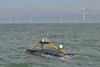
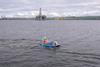
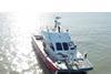
NewsUSV in Irish first
The USV represents a major step forward in reducing the carbon footprint associated with offshore survey operations
-
 News
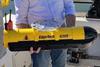
NewsSeagoing unmanned survey vessel for marine and offshore construction
A dredging contractor will deploy its first seagoing unmanned survey vessel in marine and offshore conditions.
-
 News
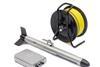
NewsCombining swath bathymetry and side scan sonar
A specialist in high resolution sonar imaging systems and underwater technology, has recently introduced a new combined swath bathymetry & side scan sonar system.
-
 News
NewsSmall vessel and USV optimised survey software
Danish hydrographic survey specialist company EIVA has released a new entry-level version of its popular hydrographic survey software.
-
 News
NewsCable survey challenge
One US-based marine environmental consulting and survey company recently completed a challenging multidisciplinary telecom cable route survey.
-
 News
NewsManor renewable energy order
Manor Renewable Energy (MRE) is continuing to invest in its survey capability.
-
News
Sonardyne brand change
Sonardyne Group Limited, a family-owned global group of companies comprising Chelsea Technologies, EIVA, Sonardyne, Voyis and Wavefront, has announced that it is rebranding as Covelya Group Limited.
-
 News
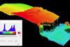
NewsDynamic dunes study
A study to help offshore wind farm development has found underwater dunes in the Dunkirk area of France are very dynamic.
-
 News
NewsFaster remote coastal mapping
Fugro RAMMS, the world’s smallest and lightest ‘deepwater’ airborne lidar bathymetry (ALB) system, can now be deployed from vessels of opportunity using a Schiebel CAMCOPTER® S-100 uncrewed aerial system (UAS).
-

-
 News
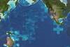
NewsFirst government signs up to seabed mapping project
As The Nippon Foundation-GEBCO Seabed 2030 gathers momentum, the first national government has signed up to this ambitious global seabed mapping project.
-
 News
NewsMarine data appointment
Ezekiel David (30) has joined Subsea Europe Services GmbH as a marine surveyor. The appointment is in line with the Hamburg-based hydroacoustic technology specialist’s growth plan, which saw the recent addition of a new Field Operations Manager and a partnership with Aberdeen-headquartered Seatronics that resulted in hundreds of hydroacoustic, and ...
-
 News
NewsCarbon conscious debris survey
Unique Group has successfully supported Well-Safe Solutions, in completing a cutting-edge, USV debris survey in the Port of Cromarty Firth, Scotland.
-
 News
NewsTransit array trial success
A new high-resolution deep-water multibeam echosounder system has just successfully completed its first trials off the coast of Florida.
-
 News
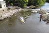
NewsUnmanned equipment for river survey
Storm Geomatics have used a SL40 USV supplied by Thurn Group in a recent wide swath bathymetric river survey.
-
 News
NewsSeafloor mapping boost
The Nippon Foundation-GEBCO Seabed 2030 Project has announced a new partnership.
-
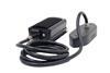
 News
NewsGeophys rental expansion
Swathe Services located in Hayle, Cornwall has recently expanded its equipment rental pool capability with a suite of GeoAcoustics products.
-
 News
NewsSubsea equipment rental partnership
Global subsea equipment rental company Seatronics, an Acteon company, and hydrographic equipment provider Subsea Europe Services GmbH (SES) have signed a reseller agreement.
-
 News
NewsReal time processing module
New Zealand Multibeam Echosounder specialist ENL Group has released the latest product in their WASSP S-Series range with the updated S3 and S3r kit with new Real-time Processing Module.
-
 News
NewsSpecialised marine data acquisition services
Nicola Offshore GmbH, a new company specialising in turnkey hydrographic survey services has started operations from its HQ in Hamburg.