![MaritimeJournal[Seawork]](https://www.maritimejournal.com/wp-content/uploads/2026/09/MaritimeJournalSeawork.svg)





OI 2002 A Predictable Success
Oceanology International 2002 at Londons ExCel Centre at the beginning of March predictably lived up to expectations as the worlds foremost marine science conference and exhibition forum, attracting a near-record attendance of 6,118 visitors from 60 countries.
With over 650 exhibitors representing nearly 400 industry disciplines, eight conference sessions and 12 vessels berthed at the neighbouring Royal Victoria Dock, participants were almost spoilt for choice by an enticing array of options in keeping with a thriving industry intent on meeting needs and aspirations dictated in part by threats posed by global climate changes.
Moreover, any sense of complacency was most definitely not on the agenda following Roger Lott’s admission at the opening conference session that ‘the hydrographic community hasn’t got its act together yet’.
Lott, Head of Survey for BP’s Upstream Technology Group, had in mind not only needs for good quality swath data, but also outstanding requirements for better integration and processing of sensor information.
Prospective solutions, however, were on plentiful display within the main exhibition halls and aboard vessel demonstrations.
Among them, with much fanfare and daily excursions down the Thames, was Sonardyne’s new Fusion system, a versatile ‘one box’ assembly claimed to meet all present and future underwater acoustic positioning and navigation requirements while eliminating recurring problems and inconveniences suffered by offshore users.
The outcome of a £3m in-house development programme, Fusion merges any combination of Long BaseLine (LBL), Ultra-Short BaseLine (USBL), Short BaseLine, GPS, Doppler Velocity Log, Inertial Navigation System (INS) and other sensor data to provide optimised navigation solutions.
In effect, says the Company, the system provides an ideal solution for simple ROV tracking tasks through to complex construction projects that have hitherto required use of separate dedicated systems.
With faster calibration and time to first fix, Fusion’s data engine is an integrated navigation controller and processor platform augmented by extensions to Sonardyne’s established Pharos software. New sub-assemblies include a series of digital transceivers in addition to Compatt 5 backward-compatible transponders offering more channels, faster performance and easier operation.
Merging of an altogether different sort was also evident from Thales Navigation with the introduction of five new GPS positioning, heading and attitude sensors now being marketed worldwide under the Ashtech name. Among them are the Ashtech Sagitta RTK positioning receiver for small and mediumsize surveys and the Aquarius 2 LRK dual GPS/GNSS system with up to 56 independent frequency channels and a heading precision of 0.01 degrees. Also of interest is the the Ashtech ADU 3, a 3D GPS position and attitude determination unit with an onboard beacon receiver for airborne, terrestrial and marine applications.
California-based Thales Navigation also announced a technological co-operation programme with TSS (UK) for joint development of new products.
The first of these, ventured Francois Erceau, Thales’ European Sales & Marketing Director for professional products, should be available towards the end of this year. Meanwhile, TSS itself announced a new fifth-generation series of Dynamic Motion Sensors (DMS) for use with single and multibeam echosounders, ROV’s and AUV’s, acoustic and dynamic positioning systems as well as other applications demanding precision motion measurements in support of IHO Class 1 survey standards. Incorporating an enhanced external velocity and heading aid algorithm for improved precision during dynamic manoeuvres, four available compact models have a quoted accuracy of 5cm or 5% (whichever is greater) at standard depth ratings of 3,000m.
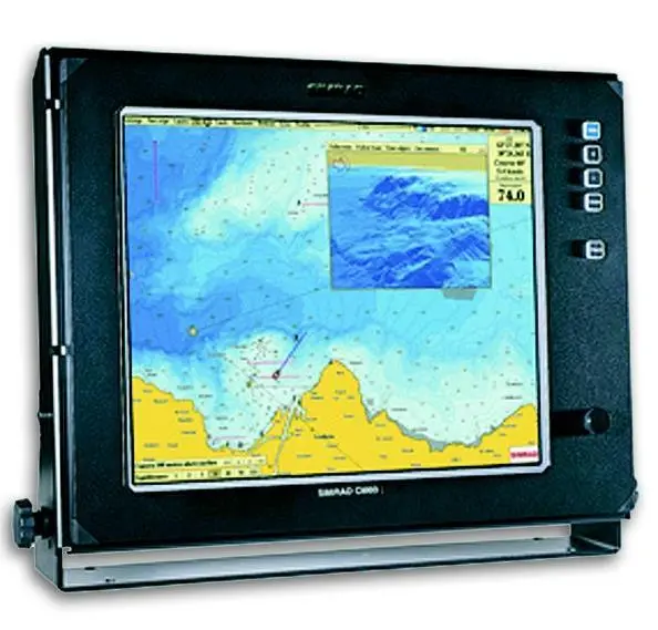
Novel flat-screen developments from Simrad of Norway included the CM60 high-speed plotter combining echosounder depth data and GPS lat/long input for production of topographic seabed maps in real-time, and a new Mk 1 version of the EK60 sounder with split beam target strength measurement and analysis for pollution monitoring and fishery applications.
Among other new sounders unveiled were two German systems, DESO 30 (a joint development with Odom Hydrographic Systems Inc in the US) from Atlas Hydrographic and the HydroStar 4900 multi-transducer unit with a depth capability of 6,000m from L-3 Communications ELAC Nautik.
New methods for providing current profile criteria in deep waters, also the subject of a conference paper by Dr Gus Jeans, featured prominently on the Fugro Geos stand while QinetiQ, the spin-off from the UK MoD’s DERA agency, launched its new Classiphi survey processing and seabed classification suite for production of mosaics and charts using sophisticated image analysis techniques for automatic classification of sidescan sonar data.
Elsewhere, the Dutch Rijkswaterstaat was among several organisations touting available facilities with the promotion of its three-deck Noordwijk offshore platform for hire to anyone interested in carrying out oceanographic and ecological studies as well testing of instrumentation. Customers to date, according to the organisation’s North Sea Directorate, have numbered NATO for radar back-scatter studies and for appraisal of sonar systems, Holland Signaal.


