![MaritimeJournal[Seawork]](https://www.maritimejournal.com/wp-content/uploads/2026/09/MaritimeJournalSeawork.svg)






Quarter of the ocean floor mapped
A quarter of the earth’s ocean floor has now been mapped, helping policy makers better understand environmental change and how to manage it.
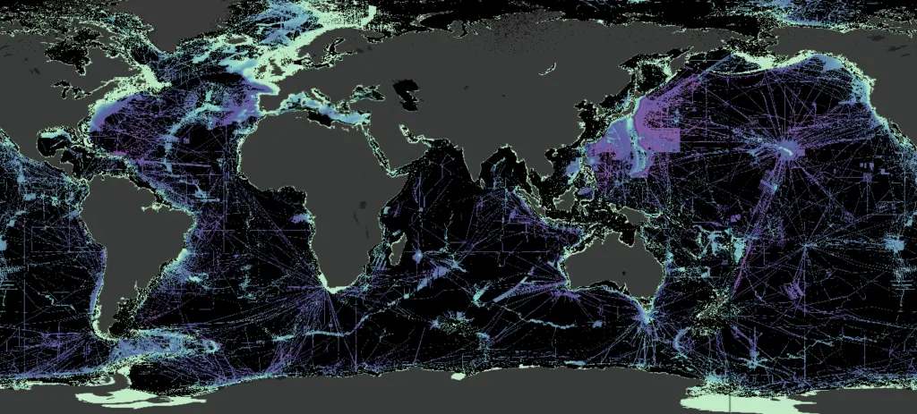
An additional 5.4 million square kilometres of new data – equating to an area twice the size of Argentina – has been added meaning 24.9% of the seabed has now been mapped.
This global effort is spearheaded by Seabed 2030, a collaborative project between The Nippon Foundation and the General Bathymetric Chart of the Oceans (GEBCO).
At Seabed’s inception in 2017 only 6% of the ocean floor had been mapped in high resolution. In that same year, the United Nations General Assembly proclaimed the ‘Ocean Decade’ with a key challenge of developing a comprehensive map of the ocean to safeguard the marine environment and its resources.
In six years, a total of 90 million square kilometres of bathymetric data has been acquired leading to developments in scientific research, as well as a range of discoveries such as 19,000 hitherto uncharted undersea volcanoes.
Even with recent progress, three quarters of the ocean remain a mystery. Some of the key challenges to mapping the entire ocean floor include overcoming the vast scale and depth, limited technological capabilities and the high-cost of mapping expeditions.
To this end, the Nippon Foundation-GEBCO training programme and the International Hydrographic Organization’s Empowering Women in Hydrography initiative aim to create a new generation of ocean mappers, dedicated to mapping the entire seafloor by the end of the decade.
“Ocean mapping is the last great exploration adventure of our time,” said Dr Mathias Jonas, Secretary-General of the IHO. “The data gathered underpins knowledge-based decision-making and will be central to the development of the digital twin of the ocean.
“It is not just a nice-to-have – it is an imperative that we work together to achieve the goal of a fully mapped ocean,” he said.
Related Articles
 OTHER NEWS
 MARINE CIVILS
 MARINE CIVILS