




Satellite trackers shed light on seaweed
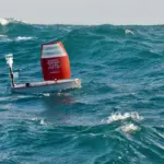
Researchers from The Netherlands are using drifter buoys fitted with satellite trackers from Globalstar Europe Satellite Services to help understand the dramatic increase of Sargassum seaweed across the North Atlantic.
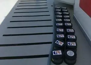
The relatively harmless Sargassum has started washing up in in such huge quantities that it is killing coral, impacting fishing and forcing the closure of beaches. By analysing the GPS data transmitted from 20 SPOT Trace trackers, the biologists hope to understand where the free-floating, kelp-like algae originates and how its environment is changing.
“Today’s climate emergency demands that we gain deeper understanding about how our oceans are changing,” said Gary King, SPOT regional sales manager EMEA at Globalstar. “Many hundreds of SPOT Trace GPS trackers are now involved in oceanography studies around the globe, helping drive informed decision-making on plastic pollution, oil spills and more, and we believe this scientific use of our reliable satellite technology will only grow further.”
The buoys are made out of a 15cm PVC pipe which floats about 1cm above the sea. Each buoy is fitted with a 7cm by 5cm SPOT Trace device which has an integrated GPS receiver, simplex transponder and motion sensor.
SPOT Trace’s oceanography customers include the University of Miami, NATO’s Science and Technology Organization Center for Maritime Research and Experimentation, the University of Oldenburg and Spain’s coastal authority, Salvamento Maritimo.
By Rebecca Strong
Related Articles
 ACCESSORIES & EQUIPMENT
 ENVIRONMENT
 MARINE CONSTRUCTION