


Underwater technology aids search for Franklin expedition shipwrecks
Early in September, a team of Canadian underwater archaeologists discovered the wreck of the HMS Erebus in the eastern stretches of the Queen Maud Gulf off the coast of Canada.
As part of the search, the team used an array of state-of-the-art technology, including advanced sonar devices, remotely operated vehicles and autonomous underwater vehicles, to at first locate and then capture images of the vessel.
The Erebus, alongside the HMS Terror, was one of the ships of the doomed Franklin Expedition that set out to traverse the last unnavigated section of the Northwest Passage in 1845 – before becoming trapped in ice in the Canadian Arctic, resulting in the death of expedition leader Captain John Franklin and 128 men.
KLEIN SYSTEM 3000
Sonar images of the shipwreck were initially captured by the Klein System 3000, a towed side-scan sonar device deployed alongside the Parks Canada survey vessel Investigator. The sensor was housed in a tow body, or towfish, that trailed behind the Investigator close to the seabed on a 200 metre armoured tow cable.
As Deborah Durgin, Marketing & Sales Supervisor at L-3 Klein Associates explained, the 3000 series Side-Scan Sonar System is a “simultaneous, dual-frequency, single-beam, digital side-scan sonar for use in general seafloor survey applications.” The system uses “advanced signal processing and core electronics functionality” from the company’s popular multi-beam side scan sonar product line to produce ‘superior quality’ side-scan imagery.
“In expeditions like this a towed array side scan will typically be used to identify the object of interest, in this case the Klein System 3000. After identifying the location of the object of interest, an unmanned underwater vehicle (UUV) with a Klein sonar payload is deployed,” said Durgin.
“The newly-developed Klein UUV-3500 high-resolution side-scan sonar for UUVs leverages a powerful, wholly FPGA-implemented, multi-channel processing engine. The sonar engine simultaneously optimises two different and concurrent output data streams for photo-quality side scan imagery and high-accuracy, co-registered swath bathymetry,” she added.
The System 3000 high-resolution side-scan uses digital technology and transducers originally developed for the Series 5000 multi-beam sonar systems. The Model 3000 produces longer ranges at high resolution from simultaneous, dual frequency (100 kHz and 500 kHz nominal) beams. In towfish configuration, the portable system has a standard depth rating of 1,500m and a modular design that can be mounted on a variety of different platforms.
“It is completely software driven on a PC platform employing Klein’s SonarPro software. SonarPro is a custom designed acquisition program developed by experienced users for ease of use by both experienced and inexperienced operators. The program features survey planning tools, navigation charts, track plotting, target management and a LAN hub interface for multiple or third party users,” said Durgin.
SAAB SEAEYE
Following the discovery of the exact location, the search team deployed a Falcon Seaeye remotely operated vehicle, or ROV, to obtain real-time video images of the Erebus. Attached by fibre optic cables to a control unit piloted by senior underwater archaeologist Ryan Harris, the ROV – which is capable of operating at depths of up to 300 metres with a 14 kilogram payload – used a high resolution colour camera on a 180° Tilt Platform to capture the footage.
“We are delighted to hear the Canadian Prime Minister say that the expedition vessels were found using an underwater vehicle, and that the Saab Seaeye Falcon ROV played a part in what he described as an historic moment for Canada,” said Matt Bates, Director at Saab Seaeye.
“Key to capturing the high quality images needed using the Falcon, was being able to fit on board the ROV a broadcast quality fibre-optics system and a high-definition camera. Its success is a testament to the Falcon’s ability to handle complex systems in the most inhospitable environments,” he added.
ARCTIC EXPLORER
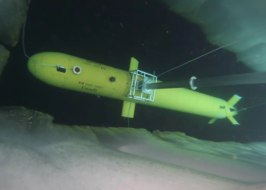
A key technology used in one of the other search areas was the Arctic Explorer, a seven metre long Autonomous Underwater vehicle (AUV) that Defence Research and Development Canada (DRDC) used to scan the seabed in the vicinity of the lost ships.
Originally developed by British Columbia-based company International Submarine Engineering (ISE) to map the Arctic seabed in support of Canada’s claim under Article 76 of the United Nations Convention on the Law of the Sea, the AUV is a modular vehicle that can be pre-programmed to carry out missions beneath the surface of the sea without any physical connection or communication with a control station. It consists of a forward free-flooding section, full diameter pressure hull and a free flooding aft section.
As Linda Mackay, Marketing & Communications Manager at ISE explained, the AUV is basically a platform ‘with a payload of many components’ that can be fitted in either of the free-flooding sections – and that can be tailored to include the specific type of sonar technology required to carry out the data mapping task at hand. This technology can include a side-scan sonar, a multi-beam echo-sounder and a sub-bottom profiler – all easily accessible though a high speed Ethernet connection. During the Franklin Expedition search the on-board technology included an ultra-high-resolution AquaPix Interferometric Synthetic Aperture Sonar (INSAS) produced by Kraken Sonar Systems, which enabled the team to capture high-resolution images at longer ranges than those possible using conventional side-scan sonar.
“The Arctic Explorer dove several times leading up to the pinpointing of the downed vessel that was spotted. With the vessel in such shallow waters, the imagery that was disseminated to the masses by government was taken with another towed body device holding a side-scan sonar,” said Mackay.
“Where ice is the challenge, you can see the advantages of the AUV’s capability to be pre-programmed and to manoeuvre under ice,” she added.
By Andrew Williams
Related Articles
 MARINE CIVILS
 MERGERS & ACQUISITIONS
 OTHER NEWS