![MaritimeJournal[Seawork]](https://www.maritimejournal.com/wp-content/uploads/2026/09/MaritimeJournalSeawork.svg)






Survey methods synchronised to study solar farm
LiDAR and bathymetric survey methods have been synchronised to study a floating solar farm and the reservoir beneath in a pilot project to combine both survey methods.
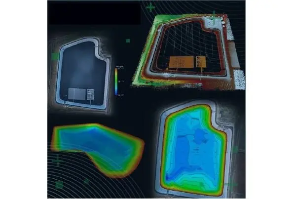
Switzerland-based high-precision survey equipment manufacturer Topodrone has carried out the synchronisation for Israeli drone provider Erelis in Israel, which was hired to study a reservoir.
Because the surface of the reservoir is covered with solar panels, standard survey methods would not be possible from a boat.
“First, aerial photgrammetry and LiDAR surveys were performed ysing a DJI M300 drone equipped with a Topodrone camera P61 amd a LiDAR hi-res system to determine the location of possible obstacles, and LiDAR scanning provided accurate detection of cables in the water,” said the company.
”Second, an underwater bathymetric survey using a Topodrone Aquamapper mounted to the same drone was conducted, avoiding detected obstacles (cables, solar panels and other objects).”
The results were, as pictured, a georeferenced orthophoto map, a 3D model of the relief and objects, and a 3D model of the bottom of the reservoir complete with contour lines and isobaths.
“Our company has been performing drone-based bathymetric surveying services for water reservoirs/basins and coastal waters since 2021,” said Erelis CEO Roman Kirsanov. “The unique ability to use the same UAV with different kinds of equipment, LiDAR systems, a high-resolution camera and Aquamapper makes it possible to unify equipment use, thereby reducing costs and eliminating the need for additional tools.”