![MaritimeJournal[Seawork]](https://www.maritimejournal.com/wp-content/uploads/2026/09/MaritimeJournalSeawork.svg)




Setting records in the Black Sea
A Surveyor Interceptor ROV from Sweden’s MMT has set new underwater records while being used for geophysical surveys to detect former land surfaces buried below the current seabed as part of the Black Sea Maritime Archaeology Project.
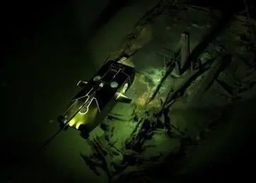
According to MMT the craft set new records for both depth of 1800 metres and a sustained speed of over 6 knots and covered a distance of 1000km.
MMT’s Surveyor Interceptor was developed for the oil and gas industry but is capable of inspecting and exploring various seabed mapping projects.
Down to 1670 metres below the surface in the Black sea, over 40 shipwrecks were found and some had never been seen before. Thanks to the anoxic conditions of the Black Sea the preservation of the remains was astonishing. This expedition provided new data on the maritime interconnectivity of Black Sea coastal communities and a glimpse into ways of life and seafaring that stretch back into prehistory.
MMTs chartered vessel Stril Explorer was used in this project.
By Jake Frith
Related Articles
 OTHER NEWS
 MARINE CIVILS
 MARINE CIVILS