


All Seabed Mapping articles
-
 News
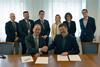
NewsSaildrone boosts European maritime surveillance
Saildrone has opened a Danish subsidiary to boost European maritime security with autonomous surveillance and seafloor mapping
-
 News
NewsSmart FEC: the backbone that keeps vital data flowing
Forward error correction (FEC) has become a trusted delivery vessel for critical data and video at sea. KenCast CEO Dr Henrik Axelsson explains how this unsung hero keeps, vessels moving, the seabed mapped and collisions at bay.
-
 News
NewsGeoAcoustics expands hydroacoustic offering in Asia
Oceanscan Singapore is GeoAcoustics’ new channel partner, covering Singapore, Malaysia, Thailand and the Philippines
-
 News
NewsDamen Shiprepair Vlissingen’s largest vessel refit contract to date
The refit of REV Ocean includes both interior and exterior enhancements and will take place at DSV’s covered drydock
-
 News
NewsTeledyne’s Swedish deal for subsea mine counter measures
Sweden will be equipped with cutting-edge subsea technology to enhance its naval operations courtesy of Teledyne
-
 News
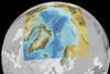
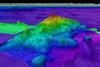
NewsSeabed 2030 expands Arctic seabed mapping
New hydrographic survey data will add 1.4 million square kilometres of subsea mapping, advancing global efforts for a fully mapped ocean floor by 2030.
-
 News
NewsRobotics firm Exail joins Seabed 2030
The Seabed 2030 Project has partnered Exail to accelerate efforts in mapping the entire ocean floor by 2030.
-
 News
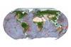
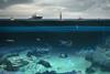
NewsSeabed 2030 maps a new area the size of Europe
The latest figure of 26.1% mapped is the latest in the global effort to uncover Earth’s final frontier
-
 News
NewsAI helps make seabed mapping quicker and easier
Seabed mapping just got quicker and easier thanks to the power of AI
-
 News
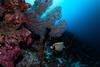
NewsLargest ever ocean species discovery programme launched
A new partnership is aiming to gain a deeper understanding of the ocean
-
 News
NewsKongsberg steps up its ocean space mapping services
Kongsberg is opening a separate business dedicated to using advanced robotics and sensor technology to map, monitor and understand ocean space
-
 News
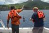
NewsUKHO supports Montserrat seabed mapping
The UKHO is helping Montserrat meet its marine monitoring obligations