


Hydrographic Survey – Page 12
-
 News
NewsHydrographic survey: technology advances the charts
Thirty years ago signified an era of tapes and magnetic disks with manufacturers plying their latest solid state microprocessor-controlled wonders to expectant users seeking data loggers generating 100 soundings per second supported by 16 and 32-bit desktop computers with 20MB memories.
-
News
World ECDIS Day
Hamburg’s Empire Riverside Hotel is the venue for this second international one-day event on Wednesday 20 September at which over 250 industry leaders are expected to be present.
-
News
UKHO seeks two new frameworks
The UK Hydrographic Office, tasked with conducting surveys in various locations around the world, is looking to establish two new frameworks for provision of lidar and swathe sounding services which will enable it to fulfill in a timely manner obligations mainly in Small Island Developing States (SIDS) that are either ...
-
 News
News£1m UXO survey contract for M² Subsea
Worldwide ROV services supplier M² Subsea, which maintains bases in Aberdeen and Houston, has been sub-contracted by Next Geosolutions of Italy under a contract worth over £1m to carry out detailed UXO (Unexploded Ordnance) removal surveys for the Nord Stream 2 twin pipeline system supplying natural gas from Russia to ...
-
News
Multibeam sounders for new Japanese Coast Guard vessels
Denmark’s Teledyne Reson is to provide extensive multibeam equipment assemblies for two new hydrographic survey vessels under construction for the governmental Japan Coast Guard (JCG) organisation.
-
News
World first remote ROV operations claimed
The world’s first commercial ROV operations conducted direct from a newly developed onshore dual control centre at its Norwegian headquarters in Bryne have begun, say subsea specialists IKM Subsea.
-
 News
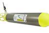
NewsMicro-AUV development
Marine science technology specialists Planet Ocean of Camberley in Surrey, UK, has developed a new range of mini Autonomous Underwater Vehicles claimed to be around three times smaller than any other comparable systems. At around 50cm long, their miniature size allows them to be used in ways not previously ...
-
News
‘Celtic Explorer’ interactive virtual tours
Opportunities to jump on board the Irish Marine Institute’s multi-purpose research vessel, the 65.5 metre ‘Celtic Explorer’, using new interactive 360 virtual tour facilities have been introduced by the organisation.
-
News
Seawork debut for iXBlue catamaran
iXBlue, the specialist French navigation, positioning and imaging organisation operating in over 30 countries, launched at Seawork International its latest all-purpose catamaran designed for hydrographic, oceanographic and biological missions, iXCat 80.
-
 News
NewsNew Fugro vessel begins offshore operations
Fugro’s latest all-purpose survey vessel, ‘Fugro Venturer’, has begun maiden operations in the deep waters of Ireland’s Atlantic margins followed by far north sectors of the Barents Sea.
-
 News
NewsUSV for seismic operations
Norway''s Maritime Robotics specialises in the development of unmanned craft and following extensive trials the company has developed the Mariner USV which is claimed to be a revolutionary tool for seismic operation.
-
 News
NewsKongsberg enters vessel market
Norway’s Kongsberg, the leading equipment manufacturer, has developed its first-ever survey vessel designed for integrating all necessary sensors for rapid operation in shallow and coastal waters as well as waterways, the GeoSwath Compact Survey Vessel (CSV). It was first shown and demonstrated at the recent Ocean Business event in ...
-
 News
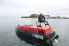
NewsCheetah Marine export successes
Isle of Wight, UK catamaran builder Cheetah Marine plans to exhibit at Seawork International a new 8.5m hydrographic craft prior to its delivery to SinoHydro, a Chinese hydropower and construction company engaged in building a multi-purpose bridge project in Bangladesh.
-
News
Anglo-Canadian underwater mapping venture
Subsea technology leaders Sonardyne International in Hampshire, UK and 2G Robotics of Ontario, Canada are to formally collaborate on the development and promotion of a dynamic underwater laser mapping system which they say will significantly reduce the time needed to survey seafloor sites and offshore structures.
-
News
New Caris software
Canadian software specialist Teledyne Caris has extended its widely-adopted HIPS and SIPS suite of products with introduction of HIPS Essential designed to meet the needs of ports and waterways, small survey companies and same-size hydrographic organisations.
-
News
Fugro Mareano survey for Norwegian Hydrographic Service
Dutch survey conglomerate Fugro has begun an own-ship survey of approximately 15,000 square km of Norwegian territorial waters on behalf of the government’s Hydrographic Service under a contract reportedly worth around €3.8m.
-
 News
NewsRegal opening for IHO Assembly in Monaco
Proclaiming the familiar lament that there’s more and better high-resolution mapping of Venus and Mars than there is of Earth’s deep oceans, Prince Albert II of Monaco, a noted marine science devotee, also reminded a packed audience at the opening of the International Hydrographic Organization’s inaugural three-year Assembly from 24-28 ...
-
News
World Hydrography Day
Mapping Our Seas, Oceans & Waterways - More Important Than Ever is the theme of this year’s UN-sponsored World Hydrography Day due to be marked worldwide on and around 21 June.
-
 News
NewsThird multibeam assembly for Hamburg Port
Hamburg Port Authority (HPA), one of Germany’s leading terminals accustomed to conducting around 900 surveys per year, has acquired a third dual head multibeam echosounder for installation aboard its smallest of three hydrographic vessels responsible for monitoring and documenting shallow water confines, ‘Deepenschriewer IV’.
-
News
Danish venture for iSurvey
Norway’s iSurvey group is to carry out survey and positioning operations under a four-year contract with Maersk Oil in support of rig move operations in the Danish sector of the North Sea.