![MaritimeJournal[Seawork]](https://www.maritimejournal.com/wp-content/uploads/2026/09/MaritimeJournalSeawork.svg)




Insurers use marine GIS to mitigate risk
In an exercise undertaken with the World Wildlife Fund, insurer RSA has used the latest Geographic Information Systems to show how technology could help predict the spread of an oil spill – helping both the marine industry and environmentalists predict, and minimise, the damage a spill could cause.
Richard Turner, director Global Marine at RSA explains the benefits such technologies hold.
The use of Geographic Information Systems (GIS) in insurance situations is nothing new. For an industry that looks to examine, understand and mitigate risks to our clients, scenario planning software is a must. At RSA we have been using it since 2002 in areas as diverse as managing risk accumulation, gauging whether too much business is being done in a given area, to property classes.
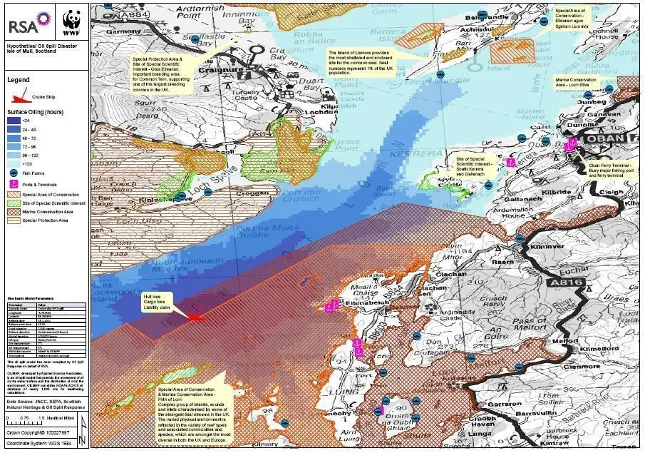
But across the marine insurance sector its use is far less common, despite the benefits GIS presents, both to the insurer and the client. A good example of these benefits was highlighted in a scenario we recently worked on with the World Wildlife Fund (WWF) that was developed to show how GIS can be used to plot the risks to wildlife and commercial shipping of an oil spill off the Scottish coast. The mapping exercise gave unprecedented levels of detail on the spread of the oil in the five days following the spill, mapping where the oil would most likely spread to and thereby highlighting which local marine conservation areas, fish farms, ports and sites of scientific interest were at risk.
The GIS also allowed RSA to map where commercial activity and environmentally sensitive areas overlap, helping both RSA and WWF to raise awareness of threats, either to environmental hotpots such as marine conservation areas or insured interests such as fish farms, terminals or ports.
As an initial example of how the technology could be used elsewhere, this exercise showed the potential of better risk management profiling for the marine insurance industry. As seen in the Gulf of Mexico, the impact across industries of a spill can be catastrophic, to fisheries, tourism and other maritime companies working nearby.
Pre-emptive identification through scenario mapping benefits all parties and has the potential to greatly enhance the commercial sustainability of the marine industry. For insurers it gives a superior understanding of the risk profile of marine clients, which in turn affects underwriting criteria, the degree of reinsurance needed and the extent of exposure in the event of a catastrophe. And as ever with insurance, greater levels of details are to the eventual benefit of the clients.
For the marine industry and its insurers the potential inherent in GIS is increasing hand-in-hand with the ever growing volumes of shipping vessels both in port and at sea. Given also the massive importance of marine biodiversity and our reliance on fish stocks as populations expand, this type of technology will prove ever more valuable in helping commercial activities manage their risk exposure whilst improving efficiencies and aiding the environment.
Using technology such as GIS looks set to become best practice by insurers over the coming years. As responsible industries we should always look to make the best use of new technologies where possible to help identify and mitigate risks. After all, it is in all parties’ interests to see where risks lie and do all we can to minimise them.