![MaritimeJournal[Seawork]](https://www.maritimejournal.com/wp-content/uploads/2026/09/MaritimeJournalSeawork.svg)






Oil spill response tool
America’s CSA Ocean Sciences Inc (CSA) has created a new GeoPortal for tasks associated with streamling the planning, science and operations for oil spill response.
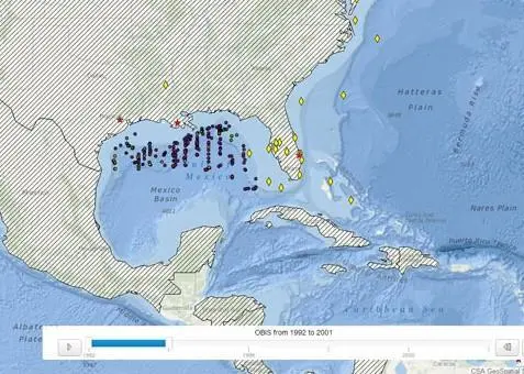
The GeoPortal serves as a tool for streamlining the planning, visualisation, and coordination efforts of multiple contractors working on a cooperative damage assessment.
Senior Scientist Dr Jodi Harney, CSA, said: “The GeoPortal has improved coordination, integration, and communication among teams responding to the incident and is providing a framework for subsequent data analysis and assessment.”
A spokesperson for CSA told Maritime Journal that the GeoPortal is a game changer because it allows the offshore industry to access real-time information essential to the collaboration and decision making, especially in times of crisis.
Functionality includes enabling the tracking of multiple field teams on small vessels through SPOT real-time communicators; guiding operational decision-making based on observed progress of field teams; and providing an ability to assess transit times to, from, and between various study areas to improve field team efficiency, safety, and integration.
By providing a common frame of reference, the GeoPortal allows team members to learn by experience by storing and displaying project-specific spatial data, including oiling observations over time, sampling designs, and sampling results.
Spatial data integrated into the GeoPortal also includes GPS digital still photographs collected by field teams in airplanes, helicopters, boats, and on foot. The availability of these resources in one online location can substantially improve communication and understanding among team members, regardless of location.
The GeoPortal provides intake capacity for field data and seamless migration into an enterprise database which allows for real-time decision making to guide incident response decisions. The common operating platform is supported by ESRI’s ArcGIS Server technology, which allows for “big picture” visualisation and analysis.
This application is part of CSA’s Marine Environmental Services for Spill Response.
Related Articles
 ACCESSORIES & EQUIPMENT
 ENVIRONMENT
 MARINE CONSTRUCTION