


Hydrographic Survey – Page 4
-
 News
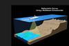
NewsAt the frontiers of subsea survey technology
A UK company is pushing at the frontiers of subsea geotechnical survey technology
-
 News
NewsOSW developers called on to data share
The cost and risk of developing wind farms could be reduced if developers were willing to share survey data, a panel has suggested.
-
 News
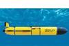
NewsTeledyne launches Sentinel glider, snaps up Valeport
Oceanology formed the backdrop for a Teledyne acquisition and product launch in London this week.
-
 News
NewsExail launches 16m USV with 30-day endurance
DriX O-16 is a new transoceanic USV with multi-robot deployment capabilities for subsea operations
-
 News
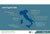
NewsItaly starts entire coastal mapping project
The most modern sensor and monitoring technology is being deployed to map Italy’s entire coastal habitats.
-
 News
NewsUS hydro survey expertise for French windfarm project
Zupt is entering the European offshore renewables market
-
 News
NewsActeon inks major subsea service contract with Siemens
The Acteon Group have inked a three-year deal for subsea survey of the Butendiek offshore windfarm
-
 News
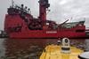
News‘Fugro Resilience’ PSV given new role
A platform service vessel (PSV) used in the oil and gas industry has been converted into a geotechnical survey vessel to be used around offshore wind farms.
-
 News
NewsMarine data in tomorrow’s remote and autonomous world
Marine technology company Ocean Infinity talks about data management in operations where more and more remote and autonomous vessels are being deployed.
-
 News
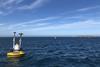
NewsCurrent monitoring provides key navigational data
ABP Southampton and marine data specialist OceanWise have teamed up on a current monitoring project to help pilots better navigate the approach to Southampton Water
-
 News
NewsAI helps make seabed mapping quicker and easier
Seabed mapping just got quicker and easier thanks to the power of AI
-
 News
NewsOEG Renewables buys marine surveyor
Offshore wind firm OEG Renewables (OEGR) has bought marine surveying company Geosight to strengthen what it can offer in offshore renewable energy, subsea cables and marine civils, it says.
-
 News
NewsDutch wind farm survey double for Fugro
Fugro is supporting energy transition in the Netherlands
-
 News
NewsFugro to run offshore wind farm study
Fugro has been chosen to conduct a metocean study for a 100 MW floating offshore wind farm in Scotland
-
 News
NewsRovco survey expertise for Scottish floating offshore windfarm
Rovco will carry out a geo-environmental survey the planned Cenos floating offshore windfarm
-
 News
NewsUKHO appoints new national hydrographer
The UK Hydrographic Office (UKHO) has announced the appointment of Rear Admiral Angus Essenhigh OBE as the United Kingdom’s new national hydrographer.
-
 News
NewsFugro continues Norway seabed mapping
Fugro is continuing to map Norway’s seabed to help preserve marine resources
-
 News
NewsAutonomous subsea surveys at German wind farm
Autonomous underwater inspections have been given the greenlight at a German offshore wind farm
-
 News
NewsCurrent profiler integrates edge processing
Sonardyne has unveiled its Origin Acoustic Doppler Current Profilers (ADCPs) with the claim that the Origin 600 stands out as the first ADCP to integrate an acoustic modem and advanced onboard edge processing.
-
 News
NewsSaildrone expands fleet with mid-sized USV
Saildrone has expanded its fleet with a mid-sized vessel that will assist in law enforcement as well as carry out ocean mapping.