


Hydrographic Survey – Page 25
-
News
OceanWise Extends Marine Mapping Dataset
Independent marine data management and publishing specialist OceanWise has further refined Marine Themes, its leading marine mapping dataset, by replacing chart-derived data with definitive datasets from bona fide sources wherever possible.
-
 News
NewsNew ROVs for Specialist Subsea Services
Aberdeen-based Specialist Subsea Services, ROV supplier and surveyor, has increased its fleet of work-class ROVs to six with the acquisition of two Schilling-HD 150hp systems from FMC Schilling Robotics of California worth over £4m.
-
 News
NewsVeripos Moves to New HQ
GNSS positioning specialist Veripos, which recently celebrated its 25th anniversary following acquisition by Hexagon AB of Sweden for a reported £90m, has moved to new purpose-built headquarters in Dyce, Aberdeen.
-
News
€3.6m Norwegian Hydrographic Service Contract for Fugro
Fugro OSAE of Bremen, Germany, has been awarded a €3.6m contract by the Norwegian Hydrographic Service for surveys over an area of 13,200 square km in the Barents and Norwegian Seas.
-
News
Global Equipment Market Worth $2.9 Billion by 2020
The global hydrographic equipment market is expected to be worth in excess of $2.9bn by 2020, according to an assessment by research analysts MarketsandMarkets (M&M) of Dallas.
-
News
World Hydrography Day
''Hydrography - More Than Just Charts'' is the theme chosen by the International Hydrographic Organization in Monaco for this year’s UN World Hydrography Day on 21 June.
-
News
Shallow Survey 2015
Expressions of interest are sought from appropriate equipment manufacturers and suppliers for contributions to a Common Data Set collection, to be used as a focal point at the 7th International Conference on High Resolution Surveys in Shallow Water at Plymouth University from 14-18 September next year.
-
News
Anglo-French working agreement
Applied Acoustic Engineering (AAE) of Great Yarmouth UK, manufacturers of subsea navigation and positioning systems and seismic survey equipment, is to collaborate with iXBlue, its French counterpart, in development of cross-compatibility between their respective acoustic positioning products.
-
News
Osiris boosts geophysical survey capability
Osiris Projects has purchased ten new Survey Engine software processing licenses from Coda Octopus. This significant investment in the Survey Engine family of geophysical processing software includes nine purchases of the new Mosaic+ professional side-scan mosaicking package which was launched at OI14.
-
News
Ashtead completes £7m investment programme
Subsea equipment specialist Ashtead Technology of Aberdeen UK, which also maintains bases in London, Houston and Singapore in addition to a global network of agents, has completed a £7m investment programme.
-
 News
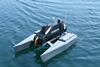
NewsFrench catamaran USV for inland waters
CAT-Surveyor, a new battery powered catamaran-type drone with a payload of 80kg and either tele-operated or automatic navigation modes, has been developed by Marseille based Subsea Tech.
-
 News
NewsFugro launches training centre
Dutch survey conglomerate Fugro has launched a new UK marine training centre to address the development needs of its operational staff.
-
News
Teledyne TSS previews AHRS & INS systems
Watford UK based Teledyne TSS has previewed its new series of advanced Saturn fibre-optic AHRS and INS (Attitude and Heading Reference and Inertial Navigation Systems) units, the outcome of a two year development programme.
-
News
Hydro 14 Call for Papers
Abstracts of papers for presentation at the International Federation of Hydrographic Societies’ 22nd conference and exhibition at Aberdeen’s Exhibition & Conference Centre from 28-30 October 2014 are now invited by the organisers, The Hydrographic Society UK.
-
News
Off the shelf digital bathymetry
Eomap, the aquatic earth observation company in Gilching, Germany, has launched an off the shelf, high resolution, satellite-derived bathymetry service available via dedicated online portals as well as its business partners.
-
 News
NewsUKHO international training success
The UK Hydrographic Office at Taunton reports successful completion of its fifth annual international cartography training course for overseas students, drawn this time from hydrographic organisations in Algeria, Bulgaria, Solomon Islands, Sri Lanka, Thailand, Trinidad and Tobago and Japan.
-
News
iSurvey expands
iSurvey, the 100 strong Norwegian survey and positioning organisation in Oslo, has invested £500,000 in establishing an offshore division in Aberdeen.
-
 News
NewsInteroperability with the CSAR framework
Safe Software and geospatial software developer CARIS have made support for the CARIS Spatial Archive (CSAR) raster format for gridded bathymetry and elevation data in FME 2014, officially released last month.
-
 News
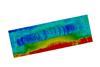
NewsCombined bathymetry and sidescan system
The EdgeTech 4600 Combined Bathymetry & Side Scan Sonar System was met with enthusiastic reviews at a recent underwater technology demonstration and training event hosted by Seatronics in Abu Dhabi.
-
News
Scandinavian ROV development
MMT, the 200 strong survey company in Gothenburg, Sweden, has teamed with Kystdesign AS of Norway in development and production of a new innovative high speed ROV designed for pipeline inspection operations and seabed surveys, Surveyor.