


Navigation & Communication
-
 News
NewsA ground-breaking spin on simulation: BMT opens ‘world-first’ DISC
BMT has officially opened a 360 degree immersive maritime testing hub, with wall-to-wall LED screens that use live AIS feed to depict real-world port scenarios.
-
 News
NewsSeawork exhibitors partner up for electric marine safety
Seawork exhibitors Hefring Marine and Ecomar Propulsion have struck a partnership that they say will improve safety and operational efficiency at sea.
-
 News
NewsBMT unveils autonomy training platform at OI
BMT has launched a ROC-Sim platform simulator designed to allow operators and developers to test and train on uncrewed maritime systems without putting vessels or personnel in the water.
-
 News
NewsOrca AI launches 360-degree AI field view platform
Orca AI has launched a version of its maritime AI platform built around a 360-degree field of view, giving vessels continuous visual coverage on all sides.
-
 News
NewsKongsberg Discovery unveils north-seeking MEMS navigation system
Kongsberg Discovery has developed a north-seeking micro-electromechanical system (MEMS) that it says represents an advance in inertial navigation technology.
-
 News
NewsPrivilège Marine integrates SEA.AI system across entire vessel range
French catamaran builder Privilège Marine will install SEA.AI technology as standard across its entire range of vessels in a shift towards integrating AI-assisted situational awareness into offshore cruising design.
-
 News
NewsAutonomous navigation software secures AiP first
The AiP for Greenroom Robotics marks the first time BV has approved software enabling fully autonomous navigation
-
 News
NewsCoastal states raise alarm over GNSS interference
Fourteen European coastal states and Iceland have issued a warning to the international maritime industry over growing risks to maritime safety from interference in satellite navigation systems and vessel data manipulation.
-
 News
NewsFrom safety to systems: how Hefring began
Iceland-based Hefring Marine did not start with autonomy in mind: to begin with it was all about safety. CEO Karl Birgir Björnsson talks to Maritime Journal about the journey to all-round data collection, enabling predictions in real time.
-
 News
NewsCutting the umbilical: Dynautics dives in with ‘Phantom Two’
Beneath the waves, radio signals die, GPS disappears and pressure mounts. It is here, far from roads, runways or rails, that true autonomy is particularly desirable; and it is here that Dynautics is quietly building its reputation. CEO Dr Henry Robinson talks to Maritime Journal about his company’s true autonomy.
-
 News
NewsOffshore wind on the CUSP of SBP breakthrough
As offshore wind capacity deployment continues to scale, developers need increasingly detailed characterisation of the seafloor to de-risk engineering activities such as cable route planning, landfall design and foundation installation.
-
 News
NewsMachine vision: A critical layer in autonomy
Autonomy in the maritime sector is often talked about as an end-state: vessels operating with minimal or no crew, navigating complex waterways without human intervention, writes SEA.AI CEO Marcus Warrelmann.
-
 News
NewsCompanies collaborate to co-ordinate safety solutions
Two maritime technology providers have integrated AI-based visual detection with onboard data recording to improve safety monitoring, event logging and post-incident analysis for vessel operators.
-
 News
NewsGNSS isn’t enough to protect workboats from jamming and spoofing
GNSS was never engineered to be robust against deliberate radio frequency interference, and as a result, they are vulnerable to jamming and spoofing. Alastair MacLeod, CEO, Ground Control, a PNT resilience provider, sheds light on how workboats can be protected.
-
 News
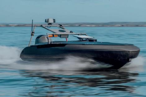
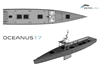
NewsZeroUSV reveals shorter timeframe for larger vessel build
UK-based ZeroUSV is building an uncrewed surface vessel (USV) that it says proves it and other SMEs can deliver ultra long-distance, high payload autonomous vessels in months rather than years.
-
 News
NewsAutonomous docking demo on river cruiser
Autonomous docking and sailing on an inland waterway has been demonstrated for what is believed to be the first time.
-
 News
NewsAnschütz unveils advanced autonomous navigation
Anschütz has unveiled its new scalable autonomous navigation system for a range of sectors
-
 News
NewsShipping Forecast more trustworthy over time
Met Office forecast accuracy has improved, enhancing safety, efficiency and decision-making across UK waters
-
 News
NewsFishing fleet nets performance benefits with Hefring tech
Seawork exhibitor Hefring Marine has partnered the Northern Ireland Fishermen’s Federation to improve vessel performance with its fuel and vessel monitoring technology.
-
 News
NewsAutonomous ships taught to read official navigation data
The UK Hydrographic Office (UKHO) has launched what it calls a world-first research programme to teach Maritime Autonomous Surface Ships (MASS) to read, interpret and act upon official navigational data.
