


Ocean Sciences – Page 5
-
 News
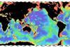
NewsMapping the entire ocean floor
The Nippon Foundation-GEBCO Seabed 2030 Project has teamed up with Global Oceans to produce a definitive map of the ocean floor.
-
News
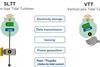
Standardising climate change data
RTSys and IFREMER have jointly developed a new system that helps standardise data collected during studies into the impact of global warming on the oceans.
-
 News
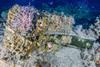
NewsOver 100 species found living on small part of 2,200-year-old shipwreck
Italian researchers have found a community of 114 species of invertebrates on a priceless underwater archeological artifact.
-
 News
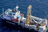
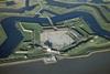
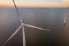
NewsCore barrel technology for challenging wind power site investigation
Geoquip Marine has successfully completed a highly challenging offshore windfarm geotechnical investigation in harsh environmental conditions off the coast of Japan.
-
 News
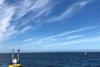
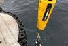
NewsLidar buoys will fact find for energy islands
Floating wind lidar measurements will be taken for what will be the world’s first offshore artificial energy island, which is being constructed for the Danish Government.
-
 News
NewsGeotechnical data analysis lab
A new laboratory testing facility will offer fast and accurate analysis of all types of geotechnical data.
-
 News
NewsCSA and GEO Marine strategic alliance
CSA Ocean Sciences Inc., an international provider of marine environmental and geomatics services, has announced that it is teaming with GEO Marine Survey Systems.
-
 News
NewsEnergy harvesting smart buoy prototypes
Nagasaki University and Kyocera Corporation have announced their joint development of an Energy Harvesting Smart Buoy.
-
 News
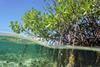
NewsBlue carbon plea
Blue carbon is a key tool in tackling global warming, yet is being largely ignored by policymakers, a new report has found.
-
 News
NewsRecord 61 grants for 2021
The Save Our Seas Foundation is celebrating an overwhelming number of applications and awards recorded in 2021.
-
 News
NewsAcoustic capability
Acoustic technology is being used to help the offshore wind industry adapt to complex oceanic environments.
-
 News
NewsNew depths for bathymetric lidar
A next generation full geospatial bathymetric lidar is believed to have the best depth performance and the highest green laser point density in its class.
-
 News
NewsProtecting biodiversity
Marine consultancy ABPmer will undertake a water management project with a biodiversity angle.
-
 News
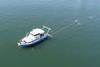
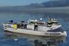
NewsResearch vessel order
Plans are in place to build a new research vessel for seismic and oceanographic work.
-
 News
NewsCoastal Inundation Challenge winner
UKHO recently ran a challenge to identify how marine geospatial data can be used to identify areas at risk of coastal inundation.
-
 News
NewsBathymetric data sustainability goal
Seabed 2030 has entered a partnership to assemble a global compilation of high-resolution bathymetric data to better enable global sustainability.
-
 News
NewsBuoy to study biocolonisation
A buoy has been launched to study biocolonisation on the site of a future North Atlantic wind farm.
-
 News
NewsSatellite-derived bathymetry for NOAA
The National Oceanic and Atmospheric Administration (NOAA) has been supplied with satellite-derived bathymetry (SDB) validated by green laser altimeter data from the NASA ICESat-2 satellite for two US shallow-water coastal areas.
-
News
Monitoring noise impacts
A Marine Data Buoy deployed off the coast of Baltimore, west Cork is to monitor how noise impacts whales and dolphins.
- Previous Page
- Page1
- Page2
- Page3
- Page4
- Page5
- Next Page